
Hermival-les-Vaux
| Hermival-les-Vaux | ||
|---|---|---|
|
||
| region | Normandy | |
| Department | Calvados | |
| Arrondissement | Lisieux | |
| Canton | Pont-l'Évêque | |
| Community association | Lisieux Normandy | |
| Coordinates | 49 ° 10 ′ N , 0 ° 17 ′ E | |
| height | 52-166 m | |
| surface | 13.76 km 2 | |
| Residents | 813 (January 1, 2017) | |
| Population density | 59 inhabitants / km 2 | |
| Post Code | 14100 | |
| INSEE code | 14326 | |
 View of the center of Hermival-les-Vaux |
||

Hermival-les-Vaux is a French municipality with 813 inhabitants (as of January 1 2017) of the department of Calvados in the region of Normandy . Administratively, it is assigned to the canton of Pont-l'Évêque (until 2015: canton of Lisieux-1 ) and the arrondissement of Lisieux . The inhabitants are called Hermivalais .
geography
Hermival-les-Vaux is located about 46 kilometers east of Caen and about 38 kilometers south-southwest of Le Havre am Paquine in the Pays d'Auge landscape . Hermival-les-Vaux is surrounded by the neighboring communities of Fauguernon in the north and north-west, Moyaux in the north-east, Ouilly-du-Houley in the east, Firfol in the east and south-east, Glos in the south, Lisieux in the south-west and Rocques in the west.
Population development
| year | 1962 | 1968 | 1975 | 1982 | 1990 | 1999 | 2006 | 2013 |
|---|---|---|---|---|---|---|---|---|
| Residents | 412 | 395 | 526 | 518 | 673 | 760 | 832 | 849 |
| Source: Cassini and INSEE | ||||||||
Attractions
- 19th century Saint-Germain church
- Remains of the Notre-Dame church in Les Vaux
- Hermival Castle from the 16th century
- Saint-Laurent mansion from the 17th century, now with a zoological garden
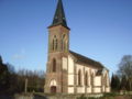
Saint Germain Church

Hermival Castle

