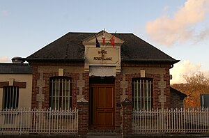
Périers-en-Auge
| Périers-en-Auge | ||
|---|---|---|
|
|
||
| region | Normandy | |
| Department | Calvados | |
| Arrondissement | Lisieux | |
| Canton | Cabourg | |
| Community association | Normandy-Cabourg-Pays d'Auge | |
| Coordinates | 49 ° 15 ′ N , 0 ° 5 ′ W | |
| height | 2–126 m | |
| surface | 5.09 km 2 | |
| Residents | 138 (January 1, 2017) | |
| Population density | 27 inhabitants / km 2 | |
| Post Code | 14160 | |
| INSEE code | 14494 | |
 Mairie Périers-en-Auge |
||
Périers-en-Auge is a French commune with a population of 138 (as at 1st January 2017) in the department of Calvados in the region of Normandy . It belongs to the Arrondissement Lisieux and the Canton of Cabourg .
geography
The municipality is located in the natural landscape of the Pays d'Auge , around 20 kilometers northeast of the city center of Caen . The river Dives runs along the western boundary of the municipality and flows into the English Channel in the neighboring municipality of Dives-sur-Mer on the Côte Fleurie . Other neighboring communities are Grangues in the east, Cricqueville-en-Auge in the southeast, Brucourt in the south and Varaville in the west.
The municipality itself consists of a large number of homesteads and hamlets : Le Lieu Thil, Le Lieu Gémare, Le Fer des Champs, La Clôture, Le Lieu Familly, Le Lieu de Bernières, Le Champ de l'Épine, Méricourt, Le Lieu Manoury , Le Moulin, La Cour de la Bergerie, Le Valacre, La Croix Kerpin, La Mare Élan, L'École, Le Lieu Gauvin, Le Clos Richard et Saint-Évroult.
Population development
| year | 1962 | 1968 | 1975 | 1982 | 1990 | 1999 | 2006 | 2015 |
|---|---|---|---|---|---|---|---|---|
| Residents | 118 | 113 | 85 | 96 | 114 | 145 | 140 | 139 |
Attractions
- Church of Périers-en-Auge
literature
- Le Patrimoine des Communes du Calvados. Volume 1, Flohic Editions, Paris 2001, ISBN 2-84234-111-2 , pp. 738-739.

