Saint-Arnoult (Calvados)
| Saint-Arnoult | ||
|---|---|---|

|
|
|
| region | Normandy | |
| Department | Calvados | |
| Arrondissement | Lisieux | |
| Canton | Pont-l'Évêque | |
| Community association | Cœur Cote Fleurie | |
| Coordinates | 49 ° 20 ′ N , 0 ° 5 ′ W | |
| height | 2-100 m | |
| surface | 5.12 km 2 | |
| Residents | 1,165 (January 1, 2017) | |
| Population density | 228 inhabitants / km 2 | |
| Post Code | 14800 | |
| INSEE code | 14557 | |
| Website | http://www.saintarnoult14.fr/ | |
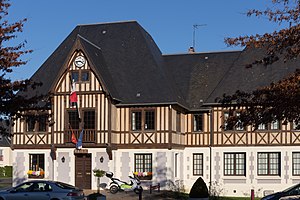
 Town hall (Mairie) of Saint-Arnoult |
||
Saint-Arnoult is a French commune with 1,165 inhabitants (as of January 1 2017) of the department of Calvados in the region of Normandy . Administratively it is assigned to the canton of Pont-l'Évêque and the Arrondissement of Lisieux . The inhabitants are called Arnulphiens .
geography
Saint-Arnoult is located about 20 kilometers south of Le Havre in the Pays d'Auge and on the Touques River , which borders the municipality to the east. Saint-Arnoult is surrounded by the neighboring communities of Deauville in the north, Touques in the northeast, Bonneville-sur-Touques in the east and southeast and Tourgéville in the south and west.
Population development
| year | 1962 | 1968 | 1975 | 1982 | 1990 | 1999 | 2006 | 2013 |
|---|---|---|---|---|---|---|---|---|
| Residents | 444 | 523 | 526 | 518 | 766 | 903 | 910 | 1,196 |
| Source: Cassini and INSEE | ||||||||
Culture and sights
- Remains of a priory from the 11th century
- Estimauville Castle from the 18th century
- Remains of Lassay Castle from the 17th century
Web links
Commons : Saint-Arnoult - Collection of images, videos and audio files

