
Bréville-les-Monts
| Bréville-les-Monts | ||
|---|---|---|

|
|
|
| region | Normandy | |
| Department | Calvados | |
| Arrondissement | Lisieux | |
| Canton | Cabourg | |
| Community association | Normandy-Cabourg-Pays d'Auge | |
| Coordinates | 49 ° 14 ′ N , 0 ° 12 ′ W | |
| height | 11-63 m | |
| surface | 4.75 km 2 | |
| Residents | 655 (January 1, 2017) | |
| Population density | 138 inhabitants / km 2 | |
| Post Code | 14860 | |
| INSEE code | 14106 | |
| Website | www.breville-les-monts.fr | |

Bréville-les-Monts is a French commune with a population of 655 (as at 1st January 2017) in the department of Calvados in the region of Normandy . The municipality belongs to the Arrondissement Lisieux and the canton of Cabourg . The inhabitants are called Brévillais .
geography
Bréville-les-Monts is located near the Côte Fleurie in the eastern valley of the Orne . Bréville-les-Monts is surrounded by the neighboring municipalities of Amfreville in the north and north-west, Merville-Franceville-Plage in the north, Gonneville-en-Auge in the north-east, Bavent in the east, Escoville in the south and south-west, Hérouvillette in the south-west and Ranville in the west.
Population development
| year | 1962 | 1968 | 1975 | 1982 | 1990 | 1999 | 2006 | 2012 |
|---|---|---|---|---|---|---|---|---|
| Residents | 301 | 387 | 441 | 529 | 515 | 565 | 677 | 650 |
Source: INSEE
Attractions
- Ruins of the old Saint-Pierre church, Monument historique
- Church from 1960
- Amphernet Castle
- Saint-Côme mansion from the 16th century
- Wash house
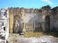
Ruins of the Saint-Pierre church
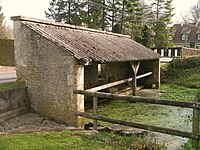
Wash house


Community partnerships
There is a partnership with the German municipality of Hillerse in Lower Saxony.