
Hotot-en-Auge
| Hotot-en-Auge | ||
|---|---|---|
|
||
| region | Normandy | |
| Department | Calvados | |
| Arrondissement | Lisieux | |
| Canton | Mezidon Canon | |
| Community association | Normandy-Cabourg-Pays d'Auge | |
| Coordinates | 49 ° 9 ′ N , 0 ° 3 ′ W | |
| height | 2-35 m | |
| surface | 24.05 km 2 | |
| Residents | 302 (January 1, 2017) | |
| Population density | 13 inhabitants / km 2 | |
| Post Code | 14340 | |
| INSEE code | 14335 | |

Hotot-en-Auge is a French commune with a population of 302 (as at 1st January 2017) in the department of Calvados in the region of Normandy . It belongs to the arrondissement of Lisieux and the canton of Mézidon-Canon (until 2015: canton of Cambremer ).
geography
Hotot-en-Auge is about 25 kilometers west-southwest of Lisieux and about 22 kilometers east-southeast of Caen in the Pays d'Auge . Hotot-en-Auge is surrounded by the neighboring communities of Basseneville in the north and northwest, Goustranville in the north, Beuvron-en-Auge in the north and northeast, Victot-Pontfol in the east, Notre-Dame-d'Estrées-Corbon with Corbon in the southeast, Belle Vie en Auge with Biéville-Quétiéville in the south and southeast, Méry-Bissières-en-Auge with Méry-Corbon , Cléville and Saint-Ouen-du-Mesnil-Oger in the south, Saint-Pierre-du-Jonquet in the southwest and Saint -Samson in the west.
Population development
| year | 1962 | 1968 | 1975 | 1982 | 1990 | 1999 | 2006 | 2013 |
| Residents | 196 | 206 | 275 | 264 | 300 | 281 | 296 | 309 |
| Source: Cassini and INSEE | ||||||||
Attractions
- Saint-Georges church from the 12th century, monument historique
- Le Ham Church
- Saint-Ouen church in Brocottes
- Wallburg
- Numerous mansions
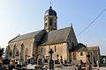
Saint-Georges church

Saint-Ouen church

Le Ham Church
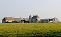
La Haute-Justice castle


literature
- Le Patrimoine des Communes du Calvados. Volume 1, Flohic Editions, Paris 2001, ISBN 2-84234-111-2 , pp. 526-530.