
İzmir – Eğirdir Railway
| İzmir – Eğirdir | |||||||||||||||||||||||||||||||||||||||||||||||||||||||||||||||||||||||||||||||||||||||||||||||||||||||||||||||||||||||||||||||||||||||||||||||||||||||||||||||||||||||||||||||||||||||||||||||||||||||||||||||||||||||||||||||||||||||||||||||||||||||||||||||||||||||||||||||||||||||||||||||||||||||||||||||||||||||||||||||||||||||||||||||||||||||||||||||||||||||||||||||||||||||||||||||||||||||||||||||||||||||||||||||||||||||||||||||||||||||||||||||||||||||||||||||||||||||||||||||||||||||||||||||||||||||||||||||||||||||||||||||||||||||||||||||||||||||||||||
|---|---|---|---|---|---|---|---|---|---|---|---|---|---|---|---|---|---|---|---|---|---|---|---|---|---|---|---|---|---|---|---|---|---|---|---|---|---|---|---|---|---|---|---|---|---|---|---|---|---|---|---|---|---|---|---|---|---|---|---|---|---|---|---|---|---|---|---|---|---|---|---|---|---|---|---|---|---|---|---|---|---|---|---|---|---|---|---|---|---|---|---|---|---|---|---|---|---|---|---|---|---|---|---|---|---|---|---|---|---|---|---|---|---|---|---|---|---|---|---|---|---|---|---|---|---|---|---|---|---|---|---|---|---|---|---|---|---|---|---|---|---|---|---|---|---|---|---|---|---|---|---|---|---|---|---|---|---|---|---|---|---|---|---|---|---|---|---|---|---|---|---|---|---|---|---|---|---|---|---|---|---|---|---|---|---|---|---|---|---|---|---|---|---|---|---|---|---|---|---|---|---|---|---|---|---|---|---|---|---|---|---|---|---|---|---|---|---|---|---|---|---|---|---|---|---|---|---|---|---|---|---|---|---|---|---|---|---|---|---|---|---|---|---|---|---|---|---|---|---|---|---|---|---|---|---|---|---|---|---|---|---|---|---|---|---|---|---|---|---|---|---|---|---|---|---|---|---|---|---|---|---|---|---|---|---|---|---|---|---|---|---|---|---|---|---|---|---|---|---|---|---|---|---|---|---|---|---|---|---|---|---|---|---|---|---|---|---|---|---|---|---|---|---|---|---|---|---|---|---|---|---|---|---|---|---|---|---|---|---|---|---|---|---|---|---|---|---|---|---|---|---|---|---|---|---|---|---|---|---|---|---|---|---|---|---|---|---|---|---|---|---|---|---|---|---|---|---|---|---|---|---|---|---|---|---|---|---|---|---|---|---|---|---|---|---|---|---|---|---|---|---|---|---|---|---|---|---|---|---|---|---|---|---|---|---|---|---|---|---|---|---|---|---|---|---|---|---|---|---|---|---|---|---|---|---|---|---|---|---|---|---|---|---|---|---|---|---|---|---|---|---|---|---|---|---|---|---|---|---|---|---|---|---|---|---|---|---|---|---|---|---|---|---|---|---|---|---|---|---|---|---|---|---|---|---|---|---|---|---|---|---|---|---|---|---|---|---|---|---|---|---|---|---|---|---|---|---|---|---|---|---|---|---|---|---|---|---|---|---|---|---|---|---|---|---|---|---|---|---|---|---|---|---|---|---|---|---|---|---|---|---|---|---|---|---|---|---|---|---|---|---|---|---|---|---|---|---|
 | |||||||||||||||||||||||||||||||||||||||||||||||||||||||||||||||||||||||||||||||||||||||||||||||||||||||||||||||||||||||||||||||||||||||||||||||||||||||||||||||||||||||||||||||||||||||||||||||||||||||||||||||||||||||||||||||||||||||||||||||||||||||||||||||||||||||||||||||||||||||||||||||||||||||||||||||||||||||||||||||||||||||||||||||||||||||||||||||||||||||||||||||||||||||||||||||||||||||||||||||||||||||||||||||||||||||||||||||||||||||||||||||||||||||||||||||||||||||||||||||||||||||||||||||||||||||||||||||||||||||||||||||||||||||||||||||||||||||||||||
| Route length: | 470.3 km | ||||||||||||||||||||||||||||||||||||||||||||||||||||||||||||||||||||||||||||||||||||||||||||||||||||||||||||||||||||||||||||||||||||||||||||||||||||||||||||||||||||||||||||||||||||||||||||||||||||||||||||||||||||||||||||||||||||||||||||||||||||||||||||||||||||||||||||||||||||||||||||||||||||||||||||||||||||||||||||||||||||||||||||||||||||||||||||||||||||||||||||||||||||||||||||||||||||||||||||||||||||||||||||||||||||||||||||||||||||||||||||||||||||||||||||||||||||||||||||||||||||||||||||||||||||||||||||||||||||||||||||||||||||||||||||||||||||||||||||
| Gauge : | 1435 mm ( standard gauge ) | ||||||||||||||||||||||||||||||||||||||||||||||||||||||||||||||||||||||||||||||||||||||||||||||||||||||||||||||||||||||||||||||||||||||||||||||||||||||||||||||||||||||||||||||||||||||||||||||||||||||||||||||||||||||||||||||||||||||||||||||||||||||||||||||||||||||||||||||||||||||||||||||||||||||||||||||||||||||||||||||||||||||||||||||||||||||||||||||||||||||||||||||||||||||||||||||||||||||||||||||||||||||||||||||||||||||||||||||||||||||||||||||||||||||||||||||||||||||||||||||||||||||||||||||||||||||||||||||||||||||||||||||||||||||||||||||||||||||||||||
|
|||||||||||||||||||||||||||||||||||||||||||||||||||||||||||||||||||||||||||||||||||||||||||||||||||||||||||||||||||||||||||||||||||||||||||||||||||||||||||||||||||||||||||||||||||||||||||||||||||||||||||||||||||||||||||||||||||||||||||||||||||||||||||||||||||||||||||||||||||||||||||||||||||||||||||||||||||||||||||||||||||||||||||||||||||||||||||||||||||||||||||||||||||||||||||||||||||||||||||||||||||||||||||||||||||||||||||||||||||||||||||||||||||||||||||||||||||||||||||||||||||||||||||||||||||||||||||||||||||||||||||||||||||||||||||||||||||||||||||||
The İzmir – Eğirdir railway is part of the Türkiye Cumhuriyeti Devlet Demiryolları (TCDD) network and connects the eponymous cities of İzmir and Eğirdir in Turkey .
history
The line was built between 1858 and 1912 in sections and with a few branches by the Ottoman Railway Company (ORC), a company equipped with British capital. It opened up the fertile hinterland of what was then Smyrna (today: İzmir) and improved its connection to the central market and export port.
On October 22, 1912, one of the most momentous rail accidents in the world to date occurred near Selçuk : A troop transport carrying 800 people crashed, more than 200 died, and 250 others were injured.
The ORC was nationalized on June 1, 1935, as Turkey endeavored to unite the railway lines that were in different hands on its territory in a state railway . With the Karakuyu – Afyonkarahisar railway line , which opened almost simultaneously on November 26, 1935 , the long-desired connection to the Baghdad Railway and the Anatolian Railway was created.
Route sections and commissioning
- İzmir-Alsancak - Sirinyer - Gaziemir - Seydiköy Railway Station, October 30, 1858
- Gaziemir - Torbalı , December 24, 1860
- Torbalı - Celatkahve , September 9, 1861
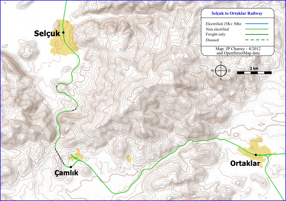
- Celatkahve - Selçuk , September 15, 1862
- Selçuk - Ortaklar - Aydin , July 1st, 1866 (end of the original plan)
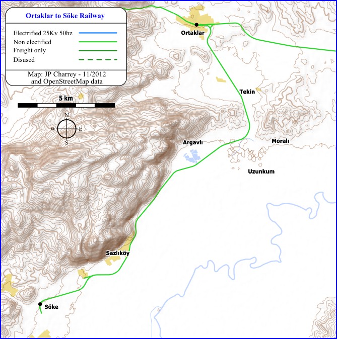
- Ortaklar - Söke , December 1, 1890
- Aydin - Kuyuçak, 1881
- Kuyuçak - Sarayköy , July 1, 1882
- Sarayköy - Goncalı - Sütlaç - Gümüşgün - Dinar , October 13, 1889
- Dinar - Egirdir , November 1, 1912
The upgrading of the line was mostly simple. There are no significant engineering structures. Only the crossing of the mountains near Aydin and the ascent to the Anatolian plateau near Sarayköy required longer inclines. The superstructure was simple. In 1935, axle loads of a maximum of only 13.5 tons were permitted.
In July 1990 the branch line from Sütlaç to Çivril was closed .
traffic
Today the suburban traffic around İzmir has the greatest importance. The remainder of the route is used several times a day to Goncalı by trains that continue on a branch to Denizli .
literature
- Benno Bickel, Karl-Wilhelm Koch, Florian Schmidt: Steam under the half moon. The last few years of steam operation in Turkey. Verlag Röhr, Krefeld 1987, ISBN 3-88490-183-4
- Neil Robinson: World Rail Atlas and historical summary. Volume 8: The Middle East and Caucasus. 2006.
Web links
Turkish railways. In: Viktor von Röll (ed.): Encyclopedia of the Railway System . 2nd Edition. Volume 9: Seaport tariffs - transition curve . Urban & Schwarzenberg, Berlin / Vienna 1921, p. 373 ff.
Remarks
- ↑ According to Robinson: "Dınar".
Individual evidence
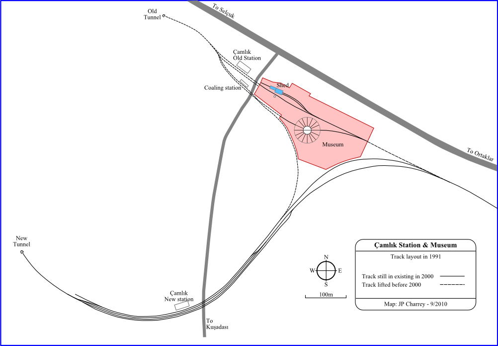
- ↑ Izmir – Denizli line. Route Çamlık. In: trainsofturkey.com. Accessed December 22, 2015 .
- ↑ Selçuk – Ortaklar line. Route Çamlık. In: trainsofturkey.com. Accessed December 22, 2015 .
- ^ Ortaklar – Söke line. Routing Ortaklar. In: trainsofturkey.com. Accessed December 23, 2015 .
- ^ Robinson, panels 7-10
- ↑ Robinson, pp. 50-55.
- ^ Şirinyer– Buca line. Route data. In: trainsofturkey.com. Accessed December 23, 2015 .
- ↑ Robinson, p. 54.