Isparta
| Isparta | ||||
|
||||
 Isparta |
||||
| Basic data | ||||
|---|---|---|---|---|
| Province (il) : | Isparta | |||
| District ( ilçe ) : | Isparta | |||
| Coordinates : | 37 ° 46 ' N , 30 ° 33' E | |||
| Height : | 1049 m | |||
| Residents : | 243,020 (2019) | |||
| Telephone code : | (+90) 246 | |||
| Postal code : | 32000 | |||
| License plate : | 32 | |||
| Structure and administration (as of 2019) | ||||
| Structure : | 44 Mahalle | |||
| Mayor : | Şükrü Başdeğirmen ( AKP ) | |||
| Postal address : | Mimar Sinan Caddesi No: 1 |
|||
| Website: | ||||
| Isparta county | ||||
| Residents : | 264,426 | |||
| Surface: | 682 km² | |||
| Population density : | 388 inhabitants per km² | |||
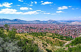
Isparta is the capital of the Turkish province of Isparta of the same name . At the same time, it is also the center of the surrounding central district ( Merkez ).
The city is located at an altitude of 1049 m in the western Taurus Mountains on the upper reaches of the Aksu and is the location of the Süleyman Demirel Üniversitesi . The province is famous for its carpets, rose cultivation and products made from rose oil .
Place name
There are various theories about the origin and meaning of the place name.
According to Süleyman Sami, the name Baris is based on the Sanskrit word vari for water . Hikmet Dağlıoğlu sees the word Baride as a place name of Hittite or Lydian origin meaning abundance . Later immigrants added the prefix ice , so that the name Eisbarida and later to Isbarida slipped away. In Turkish it became Isparta. In Byzantine times the city was called Βάρις Báris or Sbárita. In Arabic sources from the 8th century, the city is referred to as Sabarta . In Ottoman times the city was called Hamid , after the name of the beylik Hamidoğulları , which existed here in the 14th century. In 1846 the city was named Hamidabad and became the capital of a sanjak . The name was renamed back to the Turkish form of the original name in 1922.
history
The area around Isparta has been inhabited since the Paleolithic (Paleolithic); This is proven by finds in the Kapini Cave near Bozanönü, north of Isparta, which were discovered in 1944 by the Turkish archaeologist and anthropologist Şevket Aziz Kansu. Microliths from the Middle Stone Age (Mesolithic) were found near Gümüşgün, northwest of Isparta . Further traces of settlement from the Copper Age (Chalcolithic) were discovered in today's urban area. The first written sources show the existence of settlements of the Pisides , Luwians and Arzawers in the region. In the 2nd millennium BC, the Hittites tried to bring the area under their control, but they did not succeed in the long term. From 1000 BC The Phrygians immigrated and replaced the Pisiders. In the 8th century BC BC the area belonged to Lydia . 541 BC The Persians conquered Lydia under King Cyrus II . At that time a settlement called Baris is said to have existed. Alexander the Great took the area after the conquest of Sagalassos in 334/332 BC. In possession. After his death it was part of the kingdom of Pergamum until the last king of Pergamum, Attalus III. , bequeathed to the Romans.
Christianity developed quickly in Byzantine times and the participation of a Bishop Heraclius from Baris is recorded from the First Council in Nicaea in 325. A bishop from Baris, Leo, also took part in the Second Council of Nicaea in 787, although it is unclear whether Baris in Pisidia or in Hellesponto is meant. Baris became a religious center of the Anatolicon theme . During the Arab invasions in the 8th century, Baris was conquered by the Abbassids in 774 , but was soon recaptured by Byzantium. The Arab raids lasted until the 10th century and prevented the city from developing. In 1204 Baris was conquered by the Rum Seljuks under Suleiman II . After the death of the last Seljuk ruler in 1307, the Hamidids of the Principality (Turkish: Beylik ) Hamidoğulları took control of Baris and called the city "Hamid". In 1324 Hamid was briefly conquered by the Mongols, but in 1328 the Hamidoğulları ruled the city again. The last of the Hamidoğulları dynasty, Hamitoğlu Kemaleddin Hüseyin Bey, sold his principality to the Ottoman Sultan Murad I for 80,000 gold pieces in 1374 (other sources: 1381) and with Hüseyin's death in 1390 the city fell to the Ottoman Empire and was named Sandschak Hamid Part of the Beylerbey Anatolia. The city suffered great damage from the Celali uprisings in the 16th and 17th centuries. Several earthquakes during this time destroyed numerous buildings. In 1780 a severe earthquake occurred that caused the Gölcük crater lake above the city to overflow, destroying two districts in the process. In 1846 the city was named Hamidabad and had 6,310 inhabitants. In 1869 the population was 11,560. According to the yearbook of Konya Province from 1882, 33,109 people lived in Hamidabad, of whom 4,524 were Greeks and 551 Armenians.
After the Russo-Ottoman War 1877–1878, many Turks emigrated from Bulgaria and settled in what is now Turkey. Turks from the Bulgarian city of Kazanlak settled in Isparta and brought their knowledge of making rose oil with them. In 1888 Müftüzade İsmail smuggled the Bulgarian oil rose ( Rosa damascena trigintipetala) to Isparta and had it cultivated there on a large scale, so that the city became the Turkish rose city ( Şehir Gül ). In 1914 54,465 people lived in the city, including 6,648 Greeks and 1,119 Armenians .
The first hospital was built in 1900, but it was destroyed by a severe earthquake in 1914. At the beginning of World War I in 1914, all Armenians were forcibly recruited to allegedly work in road construction for the army; the women and children were deported to the east. Nothing is known about their fate; they were probably victims of the Armenian genocide in 1915.
After the end of World War I, Isparta was added to the Italian zone under the Treaty of Sèvres . Italian troops marched towards Burdur and reached Isparta on June 28, 1919. A Turkish uprising in the city, which lasted until August 1919, led to the withdrawal of Italian troops to Antalya. In 1923 the city's Greek population was expelled under the Treaty of Lausanne . At the same time, Turks who were driven out of Bulgaria settled again and revived the rose oil industry. In 1936 the railway line towards Istanbul was opened. In 1976 the State Engineering and Architecture Academy was founded, from which the Süleyman Demirel University emerged in 1992.
district
The central district surrounds the city of Isparta and borders on the Gönen and Atabey districts to the north and Eğirdir district to the east . The province of Burdur forms the border in the south and west . In addition to the district town, the district consists of two other municipalities ( Belediye ): Savköy (3,522) and Kuleönü (2,669 pop .). 20 villages ( Köy ) with an average of 772 inhabitants complete the district. Six of the villages have over a thousand inhabitants: Deregümü (2,049), Yakaören (1,725), Büyükgökçeli (1,288), Aliköy (1,238), Küçükhacılar (1,073) and Büyükhacılar (1,053 inhabitants). Due to the city of Isparta (over half of the provincial population), the population density for the central district is high and is almost seven times the provincial average (of 40 inhabitants per km²).
structure
Since the territorial reform of 2014 , the municipality ( Belediye ) has the same area as the district of the same name ( İlçe ). All previous villages ( Köy ) are now districts ( Mahalle ) of the municipality. There are a total of 44 districts:
|
|
|
|
population
Population development
The following table shows the comparative population level at the end of the year for the province, the central district and the city of Isparta as well as the respective share at the higher administrative level. The figures are based on the address-based population register (ADNKS) introduced in 2007.
| year | province | district | city | ||
|---|---|---|---|---|---|
| real | % | real | % | real | |
| 2018 | 441.412 | 58.53 | 258.375 | 91.63 | 236,749 |
| 2017 | 433.830 | 57.98 | 251,531 | 91.44 | 230.011 |
| 2016 | 427,324 | 56.57 | 241,723 | 91.15 | 220.322 |
| 2015 | 421,766 | 55.83 | 235.456 | 90.93 | 214.096 |
| 2014 | 418.780 | 54.62 | 228.730 | 90.62 | 207.266 |
| 2013 | 417,774 | 53.48 | 223.430 | 90.35 | 201.873 |
| 2012 | 416,663 | 52.78 | 219.904 | 90.21 | 198,385 |
| 2011 | 411.245 | 51.92 | 213,511 | 89.97 | 192.093 |
| 2010 | 448.298 | 54.44 | 244.045 | 91.19 | 222,556 |
| 2009 | 420,796 | 50.29 | 211,614 | 89.83 | 190.084 |
| 2008 | 407.463 | 48.39 | 197.169 | 89.17 | 175.815 |
| 2007 | 419.845 | 49.11 | 206.186 | 89.60 | 184,735 |
Census results
The following population information about the city, the district, the province and the country is available for the censuses:
| region | 1965 | 1970 | 1975! | 1980 | 1985 | 1990 | 2000 |
|---|---|---|---|---|---|---|---|
| City (Şehir) | 42.901 | 50.905 | 62,870 | 86,475 | 101.215 | 112.117 | 148.496 |
| central circle (Merkez) | 14,730 | 75.166 | 86,043 | 109,972 | 127,898 | 133,061 | 170.713 |
| Province (İl) | 266.240 | 300,029 | 322,685 | 350.116 | 382,844 | 434.771 | 513,682 |
| Turkey | 31,391,421 | 35.605.176 | 40,347,719 | 44,736,957 | 50,664,458 | 56.473.035 | 67,803,927 |
politics
Municipal council
| Party / list | Election 2019 | |
|---|---|---|
| Share of votes | Seats | |
| Adalet ve Kalkınma Partisi (AKP) | 38.71% | 15 seats |
| İYİ Parti (İYİ) | 29.55% | 8 seats |
| Milliyetçi Hareket Partisi (MHP) | 28.82% | 8 seats |
| Saadet Partisi (SAADET) | 1.35% | 0 seats |
Climate table
| Isparta (997 m) | ||||||||||||||||||||||||||||||||||||||||||||||||
|---|---|---|---|---|---|---|---|---|---|---|---|---|---|---|---|---|---|---|---|---|---|---|---|---|---|---|---|---|---|---|---|---|---|---|---|---|---|---|---|---|---|---|---|---|---|---|---|---|
| Climate diagram | ||||||||||||||||||||||||||||||||||||||||||||||||
| ||||||||||||||||||||||||||||||||||||||||||||||||
|
Average monthly temperatures and rainfall for Isparta (997 m)
|
||||||||||||||||||||||||||||||||||||||||||||||||||||||||||||||||||||||||||||||||||||||||||||||||||||||||||||||||||||||||||||||||||||||||||||||||||||||
Attractions
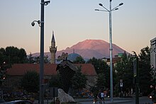
- the Kutlu Bey Cami, also: Ulu Cami (= large mosque ) a mosque from the Seljuk period, which was completed in 1299. Remodeled under Kutlu Bey in 1417. It is the oldest building in the city.
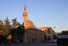
- the Firdevs-Bey-Cami (mosque) (also: Firdevs Paşa Camii, Mimar Sinan Camii) from 1561. It and the neighboring Bedesten (market hall) are attributed to the architect Sinan . Badly damaged by earthquake in 1914, then renovated.
- the Aya Payana Church (Aya Baniya Kilisesi); a Greek Orthodox church from 1750. In a ruinous state since 1923, the roof was re-covered in 1999. Another renovation is planned.
- the Ethnographic and Carpet Museum (Isparta Etnografya Halı ve Kilim Müzesi) with an impressive collection of coins and carpets.
- the Gölcük Gölü, a crater lake not quite a square kilometer in size on the Akdag Mountains at an altitude of 1,300 m, located in the southwest of the city.
Personalities
- Kemankeş Ali Pasha (d. 1624), Grand Vizier
- Halil Hamid Pascha (1736 to 1785), 1782 to 1785 Grand Vizier
- Hüseyin Avni Pascha (1819 to June 15, 1876), general, minister of war and grand vizier
- Böcüzade Süleyman Sami (January 5, 1851 to May 30, 1932), politician and author
- Süleyman Demirel (November 1, 1924 to June 17, 2015), politician, President of the State from 1993 to 2000
- Altay Yavuzaslan (September 4, 1942 to June 3, 1997), Turkish football goalkeeper
- Erkan Mumcu (born May 1, 1963), politician
- Zeki Demirkubuz (born October 1, 1964), director
- Mustafa Doğan (born January 1, 1976), football player
- Emre Aydın (born February 2, 1981), rock musician
Twin cities
| Twin town | Country |
|---|---|
| Bitlis |
|
| Comrat |
|
| Genk |
|
| Hamedan |
|
Individual evidence
- ↑ a b Türkiye Nüfusu İl ilçe Mahalle Köy Nüfusları , accessed on April 13, 2020
- ↑ http://www.isparta.gov.tr/isparta
- ^ JH Mordtmann in: Encyclopaedia of Islam, 1st edition (1913-1936); Article "Isparta", Mordtmann, JH
- ^ Raymond Janin, v. 2. Baris, in Dictionnaire d'Histoire et de Géographie ecclésiastiques vol. VI, 1932, col. 808
- ↑ http://www.isparta.gov.tr/isparta
- ↑ Kemal Karpat: Ottoman Population, 1830-1914, Demographic and Social Characteristics; in: The University of Wisconsin Press, 1985; Pp. 180-181
- ↑ Central Dissemination System / Merkezi Dağıtım Sistemi (MEDAS) of the TÜIK , accessed on June 25, 2019
- ↑ Genel Nüfus Sayımları (census results 1965 to 2000) , accessed June 26, 2019
- ↑ Isparta Merkez Seçim Sonuçları - 31 Mart Isparta Merkez Yerel Seçim Sonuçları. Retrieved May 28, 2019 (Turkish).
- ↑ Meclis Üyeler. Isparta Belediyesi, 2019, accessed May 28, 2019 (Turkish).


