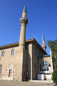
Burdur
| Burdur | ||||
|
||||

|
||||
| Basic data | ||||
|---|---|---|---|---|
| Province (il) : | Burdur | |||
| Coordinates : | 37 ° 43 ' N , 30 ° 17' E | |||
| Residents : | 90,303 (2018) | |||
| Telephone code : | (+90) 248 | |||
| Postal code : | 15,000 | |||
| License plate : | 15th | |||
| Structure and administration (as of 2019) | ||||
| Structure : | 35 Mahalle | |||
| Mayor : | Ali Orkun Ercengiz ( CHP ) | |||
| Website: | ||||
| Burdur district | ||||
| Residents : | 113,077 (2018) | |||
| Surface: | 1,567 km² | |||
| Population density : | 72 inhabitants per km² | |||
| Kaymakam : | Hasan Şıldak | |||
| Website (Kaymakam): | ||||
Burdur is the capital of a Turkish district and the capital of the province of Burdur of the same name . Burdur is located in the Mediterranean region at an altitude of 940 to 1030 meters above sea level on the southeastern bank of the Burdur Gölü , one of the deepest lakes in Turkey and at the confluence of the Kurna stream.
The district borders the province of Isparta in the north and northeast (the districts of Keçiborlu , Gönen and the provincial capital itself). The remaining borders form (internally) the districts of Yeşilova , Kemer , Çeltikçi and Ağlasun .
The district is the largest in the province (approx. 22%) and also has the highest population of all districts (approx. 42%). With a population density of around 72 inhabitants per km², it is roughly twice the provincial average.
The district consists of the district town ( Merkez ) and 51 villages ( Köy ). They have an average population of 447 people. Seven of the villages have more than a thousand inhabitants: Büğdüz (1,623), Halıcılar (1,494), Askeriye (1,463), Çatağıl (1,283), Gökçebağ (1,251), Kozluca (1,153) and Kayış (1,110 inh .). The proportion of the population of the villages in the provincial population is 20.14 percent.
history
In the immediate vicinity of the city there are evidence of the earliest settlement, which dates back to around 6,500 BC. The name of the city goes back to the Latin Praetoria and was first recorded in 1483.
In the 19th century capital of Burdur was Sanjak of Konya . In a major fire in 1884, around 150 houses were destroyed. It is estimated that more than 1,500 people were killed in a major earthquake on October 3, 1914. Two thirds of all houses were destroyed. From 1919 to 1921 Burdur was under Italian occupation. In 1923 there was another major fire in the traders' quarter, in which 250 shops were destroyed.
After the founding of the republic, Burdur became the capital of the newly formed province of the same name. According to the first census, Burdur had 12,848 inhabitants at that time. In 1936 Burdur was connected to the railway network. The population stagnated until 1955. In 1955 a sugar factory started production. This led to rapid population growth.
The Burdur Archaeological Museum presents the history of the region.
politics
Municipal council
| Party / list | Election 2019 | |
|---|---|---|
| Share of votes | Seats | |
| Cumhuriyet Halk Partisi (CHP) | 51.1% | |
| Adalet ve Kalkınma Partisi (AKP) | 44.2% | |
| Saadet Partisi (SAADET) | 2.5% | |
Population development
The following table shows the comparative population level at the end of the year for the province, the central district and the city of Burdur as well as the respective share at the higher administrative level. The figures are based on the address-based population register (ADNKS) introduced in 2007.
| year | province | district | city | ||
|---|---|---|---|---|---|
| real | % | real | % | real | |
| 2018 | 269,926 | 41.89 | 113.077 | 79.86 | 90.303 |
| 2017 | 264,779 | 40.90 | 108.297 | 78.78 | 85,312 |
| 2016 | 261,401 | 40.12 | 104,875 | 77.77 | 81,559 |
| 2015 | 258,339 | 39.45 | 101,912 | 76.86 | 78,331 |
| 2014 | 256,898 | 38.67 | 99,333 | 75.97 | 75,460 |
| 2013 | 257.267 | 38.38 | 98,743 | 75.63 | 74,680 |
| 2012 | 254,341 | 38.07 | 96,816 | 74.76 | 72,377 |
| 2011 | 250,527 | 37.86 | 94,842 | 74.15 | 70,326 |
| 2010 | 258,868 | 39.84 | 103.135 | 76.01 | 78,389 |
| 2009 | 251,550 | 38.33 | 96,422 | 74.27 | 71,611 |
| 2008 | 247,437 | 36.81 | 91,086 | 72.66 | 66,182 |
| 2007 | 251.181 | 37.93 | 95.274 | 73.64 | 70.157 |
Climate table
| Burdur (957 m) | ||||||||||||||||||||||||||||||||||||||||||||||||
|---|---|---|---|---|---|---|---|---|---|---|---|---|---|---|---|---|---|---|---|---|---|---|---|---|---|---|---|---|---|---|---|---|---|---|---|---|---|---|---|---|---|---|---|---|---|---|---|---|
| Climate diagram | ||||||||||||||||||||||||||||||||||||||||||||||||
| ||||||||||||||||||||||||||||||||||||||||||||||||
|
Average monthly temperatures and rainfall for Burdur (957 m)
|
||||||||||||||||||||||||||||||||||||||||||||||||||||||||||||||||||||||||||||||||||||||||||||||||||||||||||||||||||||||||||||||||||||||||||||||||||||||
literature
- Refik Duru: From 8000 BC to 2000 BC. Six thousand years of the Burdur-Antalya region. Suna-İnan Kıraç Akdeniz Medeniyetleri Araştırma Enstitüsü, Antalya 2008. ISBN 978-605-0027-02-0 .
Web links
Individual evidence
- ↑ a b Türkiye Nüfusu İl ilçe Mahalle Köy Nüfusları , accessed on May 18, 2019
- ↑ Yeni Şafak: Burdur Merkez İlçe Belediye Meclis Üyeliği Seçim Sonuçları - 2019 Yerel Seçim Sonuçları. May 29, 2019, accessed on May 29, 2019 (tr-TR).
- ↑ Belediye Meclisi - TC Burdur Belediye Başkanlığı. Retrieved May 29, 2019 (Turkish).
- ↑ Central Dissemination System / Merkezi Dağıtım Sistemi (MEDAS) of the TÜIK , accessed on May 18, 2019


