Kemer
| Kemer | ||||
|
||||
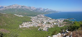
 View of Kemer |
||||
| Basic data | ||||
|---|---|---|---|---|
| Province (il) : | Antalya | |||
| Coordinates : | 36 ° 36 ' N , 30 ° 34' E | |||
| Height : | 10 m | |||
| Residents : | 42,796 (2015) | |||
| Telephone code : | (+90) 242 | |||
| Postal code : | 07 xxx | |||
| License plate : | 07 | |||
| Structure and administration (as of 2016) | ||||
| Mayor : | Mustafa Gül ( MHP ) | |||
| Website: | ||||
| Kemer County | ||||
| Residents : | 42,796 (2015) | |||
| Surface: | 468 km² | |||
| Population density : | 91 inhabitants per km² | |||
| Kaymakam : | Mustafa Cihad Feslihan | |||
| Website (Kaymakam): | ||||
Kemer is a seaside resort on the Turkish Riviera in the province of Antalya . It is located about 45 km southwest of the provincial capital Antalya in historical Lycia and is the administrative seat of the Kemer district of the same name .
The place has been shaped almost exclusively by tourism since the 1980s.
In many places the cliffs of the Taurus Mountains, which rise up to 3000 meters, reach up to the sea, so that the connecting road to the north has several tunnels. In the winter months the sun sets at 4 p.m. behind the Taurus, which rises west of the city.
To support the retail trade and to offer visitors a promenade and shopping mile, a pedestrian zone was created between the town center and a park near the beach.
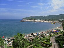
The beach consists mainly of coarse pebbles and also offers rocky spots. Some islands protrude from the sea.
Urban area
The strong, tourism-based economic growth has led to an increase in the population, although most of the residents only live in the town during the season. In recent years, the villages of Kiriş and Aslanbucak have been incorporated, and at the end of 2008 the village of Kuzdere as well. Çamyuva and Tekirova are independent cities, while Beldibi is resisting the incorporation into Antalya, which has expanded very far to the south. The provincial capital Antalya has been a Büyükşehir Belediyesi since a regional reform . This means that the district of Kemer is identical in terms of area and population to the municipality and all of the former villages and municipalities in the district are districts of the district town.
history
The plain at the foot of the soaring Taurus Mountains was created by the Ağva River , in whose former delta Kemer lies. Its main arm flows into the Mediterranean between Kiriş and Çamyuva today, and a side arm winds through Kemer. The river only carries water in winter. The region has been inhabited for around 50,000 years. This is indicated by cave finds that led to excavations in a cave near Beldibi in 1960-66 . The cave was used for a long time. Six layers can be distinguished. Iron oxide drawings and cutting tools were found.
In ancient times there was a place commonly identified with Idyros . It was located southwest of today's city center, north of the important trading city Phaselis . In the area of the former Idyros there was a church (probably from the 4th to 7th centuries), the remains of which are difficult to see. The city extended around the fortified Çalışdağ hill. However, relics from the Classical or Hellenistic period were not found during the excavations from 1976 to 1977, so that Kemer's identification with Idyros remains uncertain.
In the 13th century, the Seljuks used the area for hunting. In the first half of the century the so-called Seljuk hunting lodge was built , the function of which is unclear. It is a rectangular building, surrounded by a 15 m by 15 m long and 3 m high wall, with loopholes, and an 80 cm wide staircase that leads to the roof. It has canopy-like decorations. The stone blocks of the outer wall are tightly jointed, the wall of the building is about one meter thick. There was no entrance portal, unless it was at the point where the opening was made through the outer wall. The building was not examined until 2005. It is unclear how the two approximately three and four meter long antique columns that lie within the surrounding wall came here.
Around 1910 Kemer was still called Eski Köy ( Turkish for old village ) and was surrounded by a swampy landscape with lakes that were created by the meltwater of the mountains. The residents built a 23 km long stone wall in the foothills of the mountains to protect themselves from flooding. Because of this wall Eski Köy was renamed Kemer (English bow or belt).
Until the 1960s, Kemer could only be reached by sea. Kemer was reached in 1972 via a country road through the coastal road (D-400), which leads from Antalya to Kumluca . A more or less planned expansion began in 1980, accompanied by the South Antalya Tourism Research Project . Funds from a UN organization were made available to start the development from a fishing village into a small town exclusively geared towards tourism, which, however, tried to avoid the mistakes of mass tourism as it had begun in Spain and parts of Italy. First of all, a sewer system was laid, followed by road construction. Hotels were built according to the specifications with a limited height. Today there are numerous hotels in the city of Kemer with a total of more than 50,000 beds, most of them are four-star or five-star hotels, whereby the catering in most of the hotels has been switched to all-inclusive in recent years .
In 2006 the cable car to the 2365 m high Tahtalı Mountain was opened. In April 2010 the three tunnels between Antalya and Kemer were opened to traffic in the presence of the Turkish Prime Minister Erdoğan .
Mustafa Gül has been mayor since 2009. He had the Olbia Park renamed near the port and erected a new monument. His name was now after the Turkish captain (Yüzbaşı) Mustafa Ertuğrul Aker , who sank three ships in the First World War . Two of the wrecks are still off Kemer in the Mediterranean Sea, the Paris II about 1.5 km from the port at a depth of about 33 m. This area is at the end of the beach promenade and at the same time in the extended axis of Hafenstrasse, which is the city's main shopping street. In 2004, the aquapark there was demolished, which dates back to the early 1990s as a facility with water slides. Since most of the hotels now offered such slides themselves, the park attracted fewer and fewer visitors. In 2006 the Olbia Park was created. The name goes back to the claim that the ancient city of Olbia was west of Antalya and therefore close to Kemer. The actual ancient city of Idyros, however, was largely demolished.
Next to the mosque on Ataturk Blv. A second mosque was built in 2007 for 2,000 visitors.
The entire place has been monitored with video cameras since 2010.
traffic
Local public transport should have a bus station at junction Kemer 2, towards Aslanbucak . Until December 2007 there was an industrial park there, which was moved to Kuzdere . However, initially no investor was found. The building was inaugurated on March 15, 2009.
Town twinning
Kemer has been a twin town of Schwabach since 1998 .
Web links
Individual evidence
- ↑ Yerelnet , accessed April 8, 2016
- ↑ Yerelnet , accessed April 8, 2016
- ↑ Pictures of Idyros can be found here .
- ↑ Mogens Herman Hansen, Thomas Heine Nielsen (ed.): An inventory of archaic and classical poleis , Oxford University Press 2004, pp. 1215f.
- ↑ Pictures of the wreck: Diving ( Memento of the original from March 5, 2016 in the Internet Archive ) Info: The archive link was inserted automatically and has not yet been checked. Please check the original and archive link according to the instructions and then remove this notice.


