Covered Bridge (Cedarburg, Wisconsin)
Coordinates: 43 ° 20 ′ 16 " N , 88 ° 0 ′ 18" W.
| Covered Bridge | ||
|---|---|---|
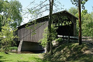
| The bridge in May 2009 | ||
| use | footbridge | |
| Crossing of | Cedar Creek | |
| place | Cedarburg ( Wisconsin ) | |
| completion | 1876 | |
| location | ||
|
|
||
The Covered Bridge (originally: Red Bridge ) is a covered wooden bridge in the Town of Cedarburg in Ozaukee County , Wisconsin in the United States. It is one of the last remaining covered bridges in this state , which once had around forty such structures. The bridge was built in 1876 to cross Cedar Creek . It has a length of 36.5 m and is made of pine wood with diagonal bars made of oak . In 1973 the structure was added to the National Register of Historic Places . It is only used by pedestrians .
history
The bridge was built in 1876 after several farmers in the area filed a petition . It was built as a permanent replacement for several bridges previously located at this point, which were torn away by floods. In 1927, a pillar was added in the middle of the structure to make the bridge passable for heavier vehicles that did not exist at the time it was built. The Ozaukee County Board took over the preservation and maintenance of the structure in 1940.
In 1960 Ozaukee County bought the bridge and land around it for $ 7,500 and established Covered Bridge County Park.
After nearly a century of uninterrupted use, the bridge began to suffer from heavy vehicle traffic and the planks came off. It was decided that the only way to preserve the structure was to reduce the load to be carried. In 1962, the commission entrusted with the maintenance of the park decided to move the bridge from its original abutments about 15 m further to the east, where it could only be used by pedestrians. Instead, a new bridge was built just a few meters west of the old structure. This new bridge is now used for motor vehicle traffic on Covered Bridge Road . The old bridge structure was added to the National Register of Historic Places on March 14, 1973 .
Building

The Covered Bridge runs in an approximately north-south oriented position over Cedar Creek. It is a lattice girder bridge made of timber , which originally had a length of 36.5 m. It has a width of 5.2 m and a height of around 5.5 m, measured from the upper edge of the abutment to the ridge of the roof. Inside, the clear height between the planks and the upper edges of the knees is around 4 m.
The structure was constructed using oak and pine lumber prefabricated near Baraboo , Wisconsin. The laths are rather thick, cut from oak and put together without the use of nails or screws. Instead, the longitudinal girdles consist of three by ten inch (7.5 cm × 25.5 cm) bars that are attached to the longitudinal beams with rounded oak dowels two inches (5 cm) in diameter. The diagonal bars measure four by seven inches (11 cm x 19 cm) and are mortised with the longitudinal girdles and secured with two oak wedges measuring two inches (5 x 5 cm) . The boards used for the bezels on the sides and ends are twelve inches (30.5 cm) wide and one inch (2.54 cm) thick, and the joints are from one to four inches (2.54 cm by 11 cm) measuring staves covered.
The roof is a pine shingle roof laid over three four inch (7.5 cm x 11) rafters spaced 30 to 36 inches (70 to 90 cm) apart.
The joists measure six by eight inches (16 cm × 21 cm) and carry upright, tightly laid wooden beams that measure two by four inches (5 × 11 cm) and form the roadway. The inside of the bridge has a wheel guard that runs about a foot (around 30 cm) above the roadway.
The abutments of the bridge are bricked with white mortar from field stones. They are 5.1 m wide below the bridge deck and widen to 5.5 m at their base. The central pillar was originally also made of field stones, but was replaced by a concrete pillar sometime before 1937.
Memorial plaque and historical markers

The Port Washington Chapter of the Daughters of the American Revolution put a plaque on the bridge, with which the structure is called the "last covered bridge in Wisconsin" and on which the dates 1876 and 1955 are given. In 1965 the Ozaukee County Historical Society erected a stake with a plaque in front of the bridge, the inscription also indicating that it was the "last covered bridge" in Wisconsin, that it was built in 1876 and "closed" in 1962.
replica
A replica of the bridge called the Springwater Volunteer Bridge was built in 1997 in Waushara County , Wisconsin.
Web links
- List of entries on the National Register of Historic Places in Ozaukee County
- List of Wisconsin bridges on the National Register of Historic Places
Individual evidence
- ↑ Town History ( English ) Town of Cedarburg. Retrieved September 1, 2012.
- ^ Early history of Ozaukee County, Wisconsin ( English ) In: University of Wisconsin Digital Collections: The State of Wisconsin Collection . University of Wisconsin. 1965. Retrieved September 1, 2012.
- ↑ a b c d e Covered Bridge Park - History ( English ) Ozaukee County Planning & Parks Department. Archived from the original on May 23, 2012. Info: The archive link was inserted automatically and has not yet been checked. Please check the original and archive link according to the instructions and then remove this notice. Retrieved September 1, 2012.
- ↑ a b Last Covered Bridge (Built 1876, retired 1962) (Historic Marker Erected 1965) . Wisconsinhistory.org. Retrieved July 22, 2012.
- ^ Dan Benson: Town of Cedarburg seeks ownership of county's Covered Bridge park ( English ) JSOnline. January 23, 2009. Retrieved September 1, 2012.
- ^ A b c Ryan Gierach: Cedarburg: A History Set in Stone . Arcadia Publishing, 2003, ISBN 978-0-7385-2431-3 , p. 145.
- ↑ Jennifer L. Herman, Federal Writers' Project of the Works Progress Administration: Wisconsin Encyclopedia (= American Guide Series). North American Book Dist LLC, 2008, ISBN 978-1-878592-61-3 , p. 438.
- ↑ Clarence W. Jahn: West Elevation and Plan of the Covered Bridge, Town of Cedarburg, Ozaukee County, Wisconsin Historic American Buildings Survey, Heritage Documentation Programs, April 2, 1934 (English)
- ^ A b c d e April 1937 survey drawing legend by report by Clarence W. John, Historic American Buildings Survey team
- ↑ a b Alexander C. Guth: Written Historical and Descriptive Data for Covered Bridge, Cedarburg, Wisconsin ( English , PDF; 96 kB) Historic American Buildings Survey. April 1937. Archived from the original on February 3, 2014. Info: The archive link was inserted automatically and has not yet been checked. Please check the original and archive link according to the instructions and then remove this notice. Retrieved September 1, 2012.
- ↑ Clarence W. John: Sections and Elevations of the Covered Bridge, Town of Cedarburg, Ozaukee County, Wisconsin Historic American Buildings Survey, Heritage Documentation Programs, April 2, 1934 (English)
- ↑ Cedarburg Covered Bridge ( English ) Bridgehunter.com. Retrieved September 1, 2012.


