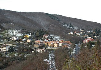
Crocetta d'Orero
| Crocetta d'Orero | |||
|---|---|---|---|
|
The pass at Serra Riccò |
|||
| Pass height | 468 m slm | ||
| province | Genoa , Liguria | ||
| Valley locations | Serra Riccò | Casella | |
| expansion | Provincial roads 2 and 3, Ferrovia Genova – Casella | ||
| Mountains | Ligurian Apennines | ||
| map | |||
|
|
|||
| Coordinates | 44 ° 31 '11 " N , 8 ° 59' 17" E | ||
The Crocetta d'Orero is a pass in the Italian region of Liguria . After the Colle di Cadibona, at 468 meters above sea level, it is the second lowest pass in the Ligurian Apennine Mountains . It is located between the Valle Scrivia and the Alta Val Polcevera on the Ligurian- Padan watershed and connects the municipalities of Serra Riccò and Casella .
At the pass there is a settlement of the same name, which belongs to the Frazione Orero . The latter is a district of Serra Riccò. The distance to the municipal administration in Pedemonte is about eight kilometers, to the municipality of Casella only two kilometers.
The pass is crossed by the Ferrovia Genova-Casella and the provincial roads SP2 and SP3.

