Val Polcevera
Coordinates: 44 ° 25 ′ 38 ″ N , 8 ° 53 ′ 19 ″ E
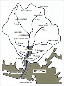
The Val Polcevera (in German: Polceveratal , in Ligurian : Pûçéivia or Ponçéivia ) is a valley in the urban area of the Italian port city of Genoa . It is traversed by the Torrente of the same name, which, together with the Bisagno to the east, delimits the historic old town of Genoa. The Polcevera flows into the Ligurian Sea between the districts of Cornigliano and Sampierdarena .
Surname
The valley was first mentioned on a bronze plaque from 117 BC. BC, the so-called Sententia Minuciorum , found. Here the valley is named as Porcobera , a combination of two Indo-European terms, which means something like “river of trout brings”. Furthermore, Pliny the Elder mentions the valley in the Third Book of Naturalis historia under the name Porcifera (77 AD). In medieval Latin , on the other hand, one encounters Pulcifera , in the 17th and 18th centuries Pozzevera or Polzevera and finally in the 19th century the current name.
geography
The Val Polcevera extends at a right angle from the coastline into the Ligurian hinterland and the Ligurian Apennines . The municipalities of Campomorone , Ceranesi , Mignanego , Sant'Olcese , Serra Riccò and the Genoese districts of Pontedecimo , Bolzaneto , Rivarolo , Sampierdarena and Cornigliano are located in the valley. The valley level is usually divided into the Bassa Val Polcevera (in German: Lower Polceveratal ), which runs from the Pontedecimo district to the river mouth, and in the Alta Val Polcevera (in German: Upper Polceveratal ). The latter also includes the side valleys with the tributaries of the Polcevera.
The wide fluvial sediment bed is characteristic of the Polceveratal , but from the 19th century on it was bordered by dams. The Polcevera, which runs perpendicular to the coastline in the lower reaches, opens in a fan shape with its source rivers in the upper reaches. In the area of the Ligurian- Padan watershed, between the Colla di Praglia and the Bocchetta Pass, there are Monte Leco (1071 meters) and Monte Taccone , which, at 1113 meters, represents the highest elevation in the valley. In the section between the Bocchetta Pass and the Crocetta d'Orero , which also includes the Giovi Pass , no Apennine elevation exceeds the 1000 meter altitude mark.
In the Levante and Ponente , the valley is bounded by the ridges of the Apennine Mountains, which run from the watershed to the Ligurian Sea. On the eastern ridge (in the Levante), which separates the Val Polcevera from the center of Genoa and the Val Bisagno , there is a fortification wall from the 17th century. Going up from Sampierdarena you come to the Belvedere district , where the Batteria Belvedere fortification used to stand and is now a sports field. Following the course of the ridge you come across a number of fortresses integrated into the city wall: Forte Crocetta , Forte Tenaglia , and the larger fortifications Forte Begato and Forte Sperone . The Forte Puin , Forte Fratello Minore and Forte Diamante are located on the more northerly elevations and outside the city wall .
The western ridge (in the Ponente) separates the Val Polcevera from the valleys of the Chiarivagna and Varenna torrents . From Cornigliano uphill it leads over the Collina di Coronata and the pass of Borzoli to the mountains Rocca dei Corvi , Teiolo , Scarpino , Monte di Torbi , Proratado and Sejeu to reach the Apennine watershed at the Colla di Praglia. In the Polceveratal, to the right of this ridge is the Monte Figogna , on which the Marian pilgrimage church Santuario di Nostra Signora della Guardia stands.

(image details of the bridge are protected by copyright, see description on Commons)
Web links
Individual evidence
- ↑ Luigi Persoglio: Memorie della parrocchia di Murta in Polcevera dal 1105 al 1873. Tipografia dello Stendardo Cattolico, Genoa 1873.
- ^ Agostino Giustiniani: Castigatissimi annali della eccelsa et illustrissima republi di Genoa. Lomellino, Genoa 1537, digitized .
- ^ A b Giovan Battista Pellegrini : Toponomastica italiana. 10000 nomi di città, paesi, frazioni, regioni, contrade, fiumi, monti spiegati nella loro origine e storia. Hoepli, Milan 1990, ISBN 88-203-1835-0 .
- ↑ Guido Arato: La mia gente. Uomini e donne della Liguria tra storia e vita quotidiana. Il Secolo XIX, Genoa 1983.

