Custer, Idaho
| Custer Historic District | ||
|---|---|---|
| National Register of Historic Places | ||
| Historic District | ||
|
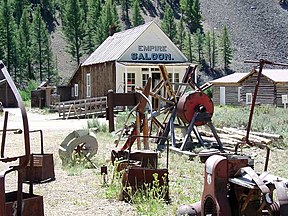
Empire Saloon in the Custer Open Air Museum, 2006 |
||
|
|
||
| location | Custer County, Idaho | |
| Coordinates | 44 ° 23 '15 " N , 114 ° 41' 45" W | |
| NRHP number | 81000207 | |
| The NRHP added | 1981 | |
Custer is a location in Custer County , Idaho and is located on the Yankee Fork Salmon River in the Salmon-Challis National Forest . The former gold rush town is now an open-air museum and no longer inhabited.
Custer was built in 1879 near the General Custer Mine named after George Armstrong Custer , which in turn gave the county its name. The history of the place is closely linked to the Bonanza settlement a few kilometers downstream. Up to the turn of the century, both places benefited from gold mining , in 1986 about 600 people lived in Custer. There was a post office , hotel and hostel, several shops, saloons and restaurants, a school, and a Chinatown . In 1904 the first two mines in the area closed. The other mines were also closed by 1911 and the settlement became a ghost town .
Since 1960, Custer has been co-managed by the Challis National Forest and maintained as an open-air museum . Volunteers, the Forest Service, and the Idaho Department of Parks and Recreation have restored several historic buildings. Custer is part of the Land of the Yankee Fork Historic Area .
Web links
Individual evidence
- ↑ Yankee Fork Road - Bonanza, Custer. In: Legends of America. Retrieved June 29, 2020 .
- ↑ Local Attractions. Yankee Fork Gold Dredge Association. Retrieved June 29, 2020 (American English).

