
Salmon-Challis National Forest
|
Challis-Salmon National Forest
IUCN Category VI - Protected Area with Sustainable use of Natural Resources |
||
 Sign at the entrance to the reserve |
||
| location | Idaho , USA | |
| surface | 17,142 km² | |
| Geographical location | 45 ° 17 ′ N , 114 ° 12 ′ W | |
|
||
| Setup date | July 1, 1908 | |
| administration | US Forest Service | |
_relief_location_map.png)
The Salmon-Challis National Forest is a 17,142 km² national forest in Idaho . The area was designated July 1, 1908 and is one of the largest in the United States. It consists of the Challis National Forest (9,969 km²) and the Salmon National Forest (7,173 km²). Like all national forests, it is federally owned and is used intensively for forestry purposes.
There are various leisure and recreational opportunities within the forest area. In addition to several campsites, the forest offers many opportunities for fishing and hunting. Several ski areas can be used in winter.
Flora and fauna
The forests of the National Forest consist mainly of Douglas fir and coastal pine . But spruces and yellow pines can also be found. These are crossed again and again by meadows or sparsely vegetated mountain areas.
The forests are home to a wide variety of animal species. So here can be bighorn sheep , moose and black bear watching. A population of bald eagles and golden eagles also live here .
Protected areas within the forest
The National Forest has three total reserves that are designated as Wilderness Area :
- Frank Church - River of No Return Wilderness (about 40% in the National Forest)
- Jim McClure-Jerry Peak Wilderness
- Sawtooth Wilderness (only around 6% are in the National Forest)
About 121 km of the Salmon River , a river in the National Wild and Scenic Rivers System , flows through the National Forest. The Sawtooth National Recreation Area is also located in the Sawtooth Mountains .
history
Originally the area was settled by the Shoshone , Nez Percé and Flathead Indian peoples . In 1805, the Lewis and Clark expedition passed through the area. The Indian participant in the Sacajawea expedition was born in what is now the National Forest. They were followed in the next few years by trappers , traders and miners who opened up the area. Ghost towns can still be found from this period.
In 1906, the Salmon River Forest Reserve was the first federal administration in this area. It was expanded on July 1, 1908 and converted to the Salmon National Forest. In the same year the Challis National Forest was established.
In 1996 the two areas were merged as part of a pilot project.
photos
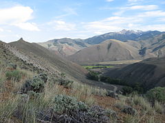
View of Sheep Mountain

Sunset in the Frank Church – River of No Return Wilderness
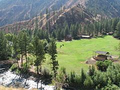
A ranch in the area

View of the Thompson Creek Mine

map


Web links
See also
Individual evidence
- ↑ "Land Areas of the National Forest (English; PDF 2.82 MB), at www.fs.fed.us in January 2012, accessed on July 12, 2017
- ↑ a b c "Information about the area" (English), www.fs.usda.gov, accessed on July 12, 2017
- ^ "Information on tourist activities" , fs.usda.gov, accessed on July 12, 2017
- ↑ "Information on the National Forest" (English), www.nationalforests.org, accessed on July 12, 2017