
Dún Aonghasa

Dún Aonghasa ( Anglicised Dun Aengus ) is an originally Bronze Age fort (Irish: dún ) on the offshore Irish island of Árainn in County Galway . The inner semicircular rampart was built about 3000 years ago, after which the outer Iron Age ramparts were added, with additional extensions until the early Middle Ages .
location

The facility on the main island of the Aran Islands is located at one of the highest points, on the edge of an almost 90 meter high cliff. Because of its historical significance and the view over the island, which on a clear day extends up to 120 km away from Mount Brandon on the Dingle Peninsula , the place became the most popular destination on Áran. From the visitor center, which houses a small museum with information about Dún Aonghasa, the prehistoric fort about one kilometer away can only be reached on foot. Particular care is required when visiting the facility on the edge of the almost 90 m high cliff eruption, as there are no safeguards. In a few places, the edge of the cliff can be entered with less risk, as rock formations form natural supports or railings.
The name Dún Aonghasa comes from the Irish god Angus , the god of love and youth.
History and context
Before the first construction phase of the stone walls in the Bronze Age there is evidence of a settlement from 1500 BC. BC, as well as the presence of wooden structures within the fortress built later. Along with Cahergall and Leacanabuaile (both near Cahersiveen ), Staigue Fort in the south of the Iveragh Peninsula all in County Kerry, Dún Chonchúir on Inis Meáin in County Galway and the Grianán of Aileach in County Donegal , the fort is one of the best restored large stone ring forts in Ireland. It is one of seven stone forts in the Aran Islands.
Form and function
The core of the complex is a semicircle 45 meters in diameter on the edge of the cliff, surrounded by the first and most powerful of the four dry stone walls . The building material is the characteristic limestone of the Aran Islands, which often breaks in straight lines and almost at right angles, as also occurs in the nearby Burren of County Clare . The innermost wall is 5.20 m wide at the base and over 6 m high, with reconstructed parts being visible through mortar connections. At the time it was used, there were some mud huts there. In the middle of the semicircle rises a stone, rectangular platform, the meaning of which is unknown. It can no longer be proven today whether the complex had a wall that had collapsed into the sea on the edge of the steep coast and possibly formed a ring wall or a D-shaped fortification. There are three more stone walls around the inner, semicircular ring, which have been preserved to varying degrees. In front of the third ring there are so-called cheval de frise in some sections , which consist of thousands of sharp stones rammed into the ground. The latter speaks in favor of its use as a defensive structure, although a function as a place of worship, as proposed for Dún Chonchúir , cannot be ruled out.
- Dún Aonghasa

Walls of the inner ring

View from the fortification over Áran

Between the inner and outer ring
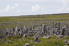
The barriers of the Cheval de Frize

entrance


Nearby are the Oghamstein and the Kilmurvy basement .
Individual evidence
- ↑ Irish excavations, The Heritage Council
- ↑ a b Dún Aonghasa ( Memento of the original from October 7, 2013 in the Internet Archive ) Info: The archive link was inserted automatically and has not yet been checked. Please check the original and archive link according to the instructions and then remove this notice. Full description at The Discovery Program
- ↑ Dún Aonghasa Visitor Center ( Memento of the original from January 14, 2015 in the Internet Archive ) Info: The archive link was inserted automatically and has not yet been checked. Please check the original and archive link according to the instructions and then remove this notice.
- ↑ Celtic culture: a historical encyclopedia , by John T. Koch, Verlag ABC-CLIO, 2006 ISBN 1-85109-440-7 , page 622f., [1]
Web links
Coordinates: 53 ° 7 ′ 31 ″ N , 9 ° 46 ′ 0 ″ W.