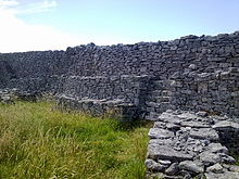
Dún Chonchúir
Dún Chonchúir [ duːn xɔnxuːɾʲ ] or in the local dialect [ duːn xrɔxuːɾʲ ] (older Irish spelling Dún Chonchobhair , English Doonconor ) is a prehistoric Dún on the Aran island of Inis Meáin , which belongs to County Galway in Ireland .
In contrast to other stone forts on the Aran Islands, Dún Chonchúir is almost oval in shape. The facility, located at the highest point on the island, measures 50 x 27 m. With a wall height of 5.5 m and almost the same thickness, its 160 m long wall is thicker than the inner wall of Dún Aonghasa on Árainn . The access is in the east. On the inside, the wall is terraced in the manner typical for systems of this typefourfold. Until the reconstruction in the 19th century, the terraces were connected by stairs. Most of them are now reconstructed. There are several niches in the wide masonry. An inner platform is accessible via steps. It is not known whether the partly reconstructed huts were part of the original use. Since no excavations have taken place in the Dún Chonchúir, the time of the construction of the facility cannot be determined. It is believed to have originated in the Iron Age . It is one of seven stone forts in the Aran Islands.
function
In English-speaking archeology, the fortification character of such systems is emphasized.
context
Dún Chonchúir belongs to Cahergall and Leacanabuaile (both near Cahersiveen ), Cathair an Lóthair , Staigue Fort in the south of the Iveragh Peninsula all in County Kerry, Dún Aonghasa in County Galway and the Grianán of Aileach in County Donegal to the best restored large stone ring forts in Ireland . It is not certain whether all the Dúns had this task. It is objected that a number of systems do not do justice to the technical tasks of a fortification: they are too small to withstand a siege (no drinking water), strategically unfavorable, have interior structures that are unsuitable for military use and unsuitable exterior systems. At Dún Chonchúir there are two ramps on the outer walls that end two meters below the top of the wall. The author concludes from this that the facilities are cult buildings.
It has been handed down from early Christian times that those clan chiefs who converted to Christianity gave their Dún to the monks. The earliest Irish monasteries were built in the former Dúns or architecturally continued the form of the Dúns in a hardly changed form. Dúns or Ráths are associated in Irish mythology with gods or the heroes endowed with godlike abilities (in the manner of Hercules ).
To Máilleach
In 1873 a man from Connemara by the name of William O'Malley ( "To Máilleach" ) lived in the fort for a few months . After he had killed his father, he fled to Inis Meáin before he could finally leave for America. Based on this story, wrote John Millington Synge his play The Playboy of the Western World ( The Playboy of the Western World ).
See also
literature
- Matthew Stout : The Irish Ringforts . Four Courts Press, 2001, ISBN 1-851-82582-7
- Jürgen E. Walkowitz: The megalithic syndrome. European cult sites of the Stone Age (= contributions to the prehistory and early history of Central Europe. Vol. 36). Beier & Beran, Langenweißbach 2003, ISBN 3-930036-70-3 .
Individual evidence
- ↑ M. Stout: "The Irish Ringfort" 1997 pp. 32-34. But he also cites: “From their dispersed distribution and the predominantly rural nature of Early Christian society, it is accepted that ringforts represent the Irish version of a common European settlement pattern known as Einzelhöfe - or dispersed individual farmsteads. This term comes from Meitzen's early work which suggested a Celtic or 'Germanic' origin for this settlement pattern. "
- ↑ Walkowitz 2003, p. 202
- ↑ Article "Elphin, County Roscommon" from the English language Wikipedia en: Elphin, _County_Roscommon : The chief of that territory, a noble Druid named Ono, gave land and afterwards his castle or fort to St Patrick to found a church and monastery.
- ↑ The Rough Guide to Ireland by Paul Gray, London, 2011
- ^ The Legendary Running Of The Máillach
Web links
- Image on Flickr.com
Coordinates: 53 ° 5 ′ 0.5 ″ N , 9 ° 35 ′ 41 ″ W.


