
Dajt
| Dajti | |||
Coordinates: 41 ° 21 ' N , 19 ° 51' E |
|||
| Basic data | |||
|---|---|---|---|
| Qark : | Tirana | ||
| Municipality : | Tirana | ||
| Height : | 200 m above sea level A. | ||
| Residents : | 20,139 (2011) | ||
| Postal code : | 1040 | ||


Dajt ( Albanian also Dajti ) is a place in Albania on the eastern outskirts of Tirana , Qark Tirana . The place in the municipality of Tirana is located at the foot of the Dajti mountain ( 1613 m above sea level ).
Until 2015 Dajt was an independent municipality ( komuna ) . The municipality comprised the entire western flank of Mount Dajti, its southern eastern flank, in the north also two villages north of the Tirana river at the foot of the Maja e Brarit and in the south parts of the western flank of Mali i Priskës ( 1365 m above sea level ) and some Villages on the east side. The community consists of the 13 villages of Linza , Shishtufina , Tujan , Brrar , Ferraj , Priska e Madhe , Surrel , Lanabregas , Shkalla , Qafëmolla , Darshen , Selba and Murth .
The rapidly growing community had over 20,000 inhabitants per year. As recently as 2009, the municipality itself reported a population of around 12,000. While the villages east of the Dajtis and the Maja e Priskës in particular are still very rural and have only a weak infrastructure, a very strong construction boom has set in in the areas on the outskirts of Tirana. Dozens of apartment blocks have been built here in an area that was previously barely inhabited, and a new community center in the lower part of Linza. Around 58% of the residents were still active in agriculture in 2009 with a population of 12,000.
The landscape of the municipality, rising from the plain of Tirana with a height of around 100 m to 1613 m above sea level. A. high summit of the Dajtis is very diverse with its hilly to mountainous character, often still forested and protected over large areas as a national park . A gondola lift leads up to the recreation area in the national park. In Linza there are various restaurants and a hotel along the road to Dajti, from where you have a good view of Tirana. Various areas on the lower slope of the Dajtis are used by the Albanian army .
On the western slope of the Dajtis at around 1200 m above sea level. A. are the remains of the Dajti castle , which was built in the 4th century and allowed control over large areas. Another fortress is located at the northwest foot of the mountain near the village of Tujan . This castle dates from around the same time and controlled the road to the east through the gorge of the Tirana River.
New buildings near Linza

New buildings, Tirana in the background

Dajti and Dajti Ekspress cable car

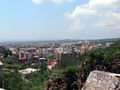
Panorama from Dajti with wide areas of the community at the bottom of the picture, behind Tirana


Individual evidence
- ↑ a b Ines Nurja: Censusi i popullsisë dhe banesave / Population and Housing Census - Tiranë 2011 . Results Kryesore / Main Results. Ed .: INSTAT . Pjesa / Part 1. Adel Print, Tirana 2013 ( instat.gov.al [PDF; accessed April 14, 2019]).
- ↑ Komuna Dajt. In: Shoqata e Komunave të Shqipërisë. Archived from the original on April 13, 2014 ; Retrieved January 8, 2011 (Albanian).
- ↑ a b Demografia. In: Komuna Dajt. October 3, 2009, archived from the original on October 26, 2012 ; Retrieved January 8, 2011 (Albanian).