Daniel Boone National Forest
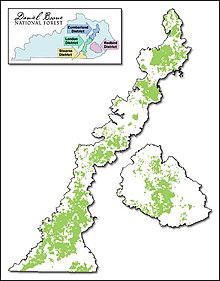
The Daniel Boone National Forest is a under the administration of the United States Forest Service -standing National Forest in the eastern part of the US state of Kentucky . It has a total area of around 2800 km² and thus comprises around five percent of Kentucky's forest area. The forest area spans 21 counties in the state; from Rowan County in the north to McCreary County in the south. The lands belonging to the Daniel Boone National Forest are partly state-owned and partly privately owned.
The Daniel Boone National Forest is divided into six districts, with five of these districts - from north to south these are Morehead, Stanton, London, Somerset and Stearns - form a contiguous area. The sixth is the Redbird district, which was purchased in 1965 and is a separate area east of the other districts. Due to the combination of natural wilderness on the one hand and a well-developed tourist infrastructure on the other, the national forest is a popular excursion area and, with over 5,000,000 visitors per year, is one of the most visited forests in the US South. Among other things, it offers numerous leisure and recreational opportunities for campers , hikers , mountaineers , anglers and hunters .
history
The national forest, named after the US national hero Daniel Boone , was founded in 1937. It was first called Cumberland National Forest , after the Cumberland River that flows through the area. In 1965 the area of the Daniel Boone National Forest was expanded with the purchase of the Redbird district. The renaming of the national forest took place in 1966 by the then US President Lyndon B. Johnson .
terrain
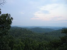
Wooded ridges, narrow valleys, waterfalls and steep sandstone cliffs along the rivers shape the image of the Daniel Boone National Forest . The national forest is home to two larger man-made lakes, Cave Run Lake and Laurel River Lake . The Red River , Cumberland River, Rockcastle River and Big South Fork River flow through the area.
In the Daniel Boone National Forest of Stanton is the Red River Gorge , an erosion- created canyon of the Red River.
One of the most famous natural monuments in the Daniel Boone National Forest is the National Arch , a 20 m high and 23 m wide rock formation created by natural erosion that rises above an arched forest area in the Somerset district.
Also worth seeing are the Cumberland Falls , bordering the national forest, in the state park of the same name .
Threats to the Forest
Economic use
In contrast to the national parks , the economic use of the National Forests is generally permitted and is partly subsidized by the state. Although originally built with the aim of preserving nature, there is therefore a constant risk of larger areas being destroyed, as almost 90% of the Daniel Boone National Forest is currently designated as possible areas for use by the timber industry.
Pests
Like many forests in the southern United States, the Daniel Boone National Forest is threatened by the Southern Pine Beetle (Dendroctonus frontalis Zimmermann). This beetle has reproduced rapidly in recent years and colonized large areas of forest.
Web links
- Official website of the USDA Forest Service (English).
Coordinates: 37 ° 13 ′ N , 83 ° 41 ′ W

