Red River (Kentucky River)
| Red River | ||
|
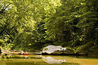
Red River in the Red River Gorge Geological Area |
||
| Data | ||
| Water code | US : 514872 | |
| location | Kentucky (USA) | |
| River system | Mississippi River | |
| Drain over | Kentucky River → Ohio River → Mississippi River → Gulf of Mexico | |
| source |
Magoffin County / Wolfe County 37 ° 40 ′ 17 ″ N , 83 ° 15 ′ 5 ″ W |
|
| muzzle | in the Kentucky River coordinates: 37 ° 51 '9 " N , 84 ° 4' 47" W 37 ° 51 '9 " N , 84 ° 4' 47" W. |
|
| Mouth height |
175 m
|
|
| length | 156 km | |
| National Wild and Scenic River , Red River Gorge | ||
|
Wild and Scenic Red River in Wolfe County |
||
|
Kentucky's Red River in the fall |
||
The Red River is a roughly 156 km long tributary of the Kentucky River , in the eastern center of Kentucky ( USA ).
It rises in the mountains of the Cumberland Plateau , on the border of Wolfe County to Magoffin County , about 15 miles east of Campton . It flows generally eastward, through Red River Gorge in Daniel Boone National Forest , then past Stanton and Clay City . About 18 km southeast of Winchester it flows into the Kentucky River.
In 1993, a 20-mile stretch of tall sandstone cliffs, waterfalls and 48 natural bridges in the Red River Gorge was designated a National Wild and Scenic River by the American federal government .
Web links
- Daniel Boone National Forest - Red River Gorge
- The Red River Saga
- RRS: Red River Gorge Biodiversity
- Arches of the Red River Gorge
Individual evidence
- ^ Red River in the United States Geological Survey's Geographic Names Information System
- ↑ National Wild & Scenic Rivers - Red River ( Memento of the original from June 10, 2010 in the Internet Archive ) Info: The archive link was inserted automatically and has not yet been checked. Please check the original and archive link according to the instructions and then remove this notice.


