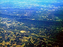
Cumberland Plateau
The southern part of the Appalachian Plateau is called the Cumberland Plateau . The plateau encompasses large swathes of eastern Kentucky , western West Virginia , Tennessee , northern Alabama, and the far northwest of Georgia . Together with the Allegheny Plateau to the northeast , the Cumberland Plateau forms the rugged plateau landscape on the western edge of the main mountain range of the Appalachians . The distinction between the Cumberland Plateau and the Allegheny Plateau is based on historical rather than geological reasons, and there is no strict boundary between the two. Both plateaus owe their names to their respective largest rivers, the Cumberland River and the Allegheny River .
geography
The Cumberland Plateau is a heavily eroded plateau with a topographical relief that is for the most part at an altitude of about 120 meters, and frequent sandstone - outcrops and cliffs. The plateau, which is rich in coal seams , has long been an important mining region.
The Pottsville Escarpment , a drop off in Kentucky that forms the transition from the Cumberland Plateau to the Bluegrass Region and the Pennyroyal Plateau , is home to numerous spectacular cliffs , canyons , rock roofs , rock arches and waterfalls . In Tennessee, the Highland Rim east of the Nashville Basin forms the western edge of the Cumberland Plateau. Its eastern edge is marked by the Walden Ridge , which extends as Sand Mountain to Alabama. The Cumberland Plateau is separated from the two by the Sequatchie Valley , which also continues to Alabama under other names.
In Kentucky, the plateau rises from northwest to southeast, reaching a height of about 60 m in the extreme west and having a shape similar to the hilly landscape of the neighboring Knobs region; further southeast, below Black Mountain , the plateau reaches a height of more than 750 meters.
Geology and physical geography
The Cumberland Plateau is part of the Appalachian Plateau, which in turn is part of the Appalachian Mountains. It is adjacent to the Allegheny Plateau, from which it only differs in fact by its name. The sedimentary rock from which both plateaus are formed come from the Mississippian and Pennsylvania and consist of offshore sediments that were washed westward from the ancient Appalachians. Some rock layers are deposited in shallow coastal water, others, including coal layers , in swampy inland regions. They are interwoven with sandstone. The layers of deposit are often interrupted. At these points they reached enough height to be eroded, but then sank and were covered by additional sediment.
flora
The plateau is home to one of the largest contiguous forest areas in the eastern United States . The predominant trees are oak and hickory , and pines are also common in the dry highlands . Mesophytes are found in some protected areas .
Individual evidence
- ↑ The Cumberland Plateau ( Memento of the original from May 20, 2011 in the Internet Archive ) Info: The archive link was inserted automatically and has not yet been checked. Please check the original and archive link according to the instructions and then remove this notice.
- ^ Physiographic divisions of the conterminous US
literature
- Harry M. Caudill: Night Comes to the Cumberlands: A Biography of a Depressed Area , Jesse Stuart Foundation, 2001, ISBN 1931672008
- Russ Manning: The Historic Cumberland Plateau: An Explorer's Guide , University of Tennessee Press, 1999, ISBN 1572330449
- Charles William Wilson: Pennsylvanian geology of the Cumberland plateau , State of Tennessee, Dept. of Conservation, Div. of Geology, 1956

