
Dardin
| Dardin | ||
|---|---|---|
| State : |
|
|
| Canton : |
|
|
| Region : | Surselva | |
| Circle : | Disentis | |
| Political community : | Breil / Brigels | |
| Postal code : | 7164 | |
| Coordinates : | 723 007 / 179 773 | |
| Height : | 1045 m above sea level M. | |
 Dardin |
||
| map | ||
|
||

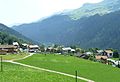
As a conglomerate of several hamlets, Dardin forms a fraction of the municipality of Breil / Brigels in the Surselva in the canton of Graubünden in Switzerland. The place is about 200 meters above the valley floor on the road to Brigels. The place name is mentioned in 765 in the will of Bishop Tello as Ardunae .
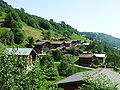
Dardin consists of the hamlets of Casu, Capaul, Casu, Caprè, Capeder and Gliz. The highest settlement Pugaus (Arpagaus) with the Caplutta Sontga Clau was abandoned around 1800. The hamlets of Plaunca and Contanaus (Cadonaus) were also abandoned. Around 150 people live in Dardin. Dardin's children go to school in Danis or Breil / Brigels.
The places are scattered along the old road from Schlans to Breil / Brigels in a Maiensäss region at an altitude of between 1000 and almost 1300 meters. Today the Senda Sursilvana runs along the old road .
The terraced cultural landscape of Dardin, which is structured by hedges and trees, has been designated an emerald area by the WWF. The Patnasa cup stones are a few hundred meters southwest of Dardin .
Attractions
Hamlet of Dardin

Dardin Capeder
Dardin Capre

Dardin Capaul (front) and Casu
Dardin Gliz
Dardin Casut


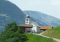
Catholic parish church St. Sebastian - S. Bistgaun

Church building

Entrance church

crucifix

banner

Mural

Detail of the arches

Memorial stone.
_16.jpg)
_10.jpg)
_06.jpg)
_07.jpg)
_04.jpg)
_10.jpg)
_22.jpg)
Web links
- Official website of the Brigels-Waltensburg-Andiast tourist region
- Adolf Collenberg: Dardin. In: Historical Lexicon of Switzerland .