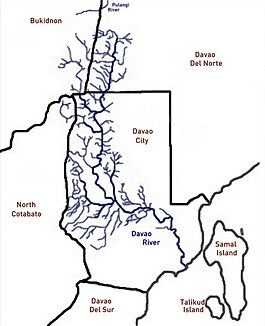
Davao (river)
| Davao | ||
|
The Davao River catchment area |
||
| Data | ||
| location | on the island of Mindanao | |
| River system | Davao | |
| muzzle | at Davao City in the Gulf of Davao Coordinates: 7 ° 4 ′ 0 ″ N , 125 ° 37 ′ 0 ″ E 7 ° 4 ′ 0 ″ N , 125 ° 37 ′ 0 ″ E
|
|
| length | 160 km | |
| Catchment area | 1700 km² | |
| Big cities | Davao City | |
|
Section of the Davao River in Davao City |
||
The Davao is a river on the southern Philippine island of Mindanao . The water catchment area of the Davao River is the third largest on the island and the seventh largest in the country.
Statistical data
The area of the river basin takes up more than 1,700 km², with a river length of 160 km. The Davao River overcomes an altitude difference of 1,875 m. Most of the area is highlands. The average amount of water transported near the mouth is 70 - 80 m³ per second. The main city on its banks is Davao City . More than 800,000 people live in its catchment area.
geography
The main source of the Davao River rises in the province of Bukidnon and flows south through Davao del Norte and Davao del Sur before it flows into the Gulf of Davao at Davao City .
Its width varies between 60 and 80 m on the lower reaches. The Suawan and Tamugan rivers are the main tributaries in its course through the Davao del Norte and Davao del Sur plains.
Importance and use
The river is an important source for the daily needs of local residents. It is used for washing as well as for bathing and as a source of food. Furthermore, the river is used as a transport route, to supply industry and housekeeping, for agriculture, cattle breeding and tourism. The various animal species that are native to the river include crocodiles .
For Davao City, it serves not least as a natural drainage channel for the rain and sewage of the metropolis.
credentials
- D Hearne, crs, proposal to HELP UNESCO, 2004


