Nillumbik Shire
| Shire of Nillumbik | |
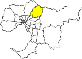
 Location of Nillumbik Shire in Melbourne |
|
| structure | |
| State : |
|
| State : |
|
| Administrative headquarters: | Greensborough |
| Dates and numbers | |
| Area : | 430 km² |
| Residents : | 61,273 (2016) |
| Population density : | 142 inhabitants per km² |
| Wards : | 9 |
Coordinates: 37 ° 41 ' S , 145 ° 7' O Nillumbik Shire is a local government area (LGA) in the Australian state of Victoria . Nillumbik is part of the Outer Metropolitan Area of Melbourne , the outer metropolitan area of the capital of Victoria. The area is 430 km² and has about 60,000 inhabitants.
Nillumbik is located 15 to 46 km northeast of downtown Melbourne, northwest of the Yarra River and contains 23 neighborhoods and towns: Arthurs Creek, Bend of Islands, Christmas Hills, Cottles Bridge, Diamond Creek, Doreen, Eltham, Eltham North, Greensborough, Hurstbridge, Kangaroo Ground , Kinglake, Kinglake West, North Warrandyte, Nutfield, Panton Hill, Plenty, Research, Smiths Gully, St Andrews, Strathewen, Wattle Glen and Yarrambat. The Shire Council is based in Greensborough in the far south west.
Gold discoveries in the middle of the 19th century increased the population in the hilly area. Sheep breeding and fruit growing replaced the residents' sources of income after the few years of gold wealth. Even today, large areas, especially in the north, are sparsely populated, agriculturally used land.
The Sugarloaf Reservoir is a 440 hectare reservoir in the Christmas Hills area in the east of the Shire, which provides water to the northwest and parts of downtown Melbourne. In the northeast are parts of Kinglake National Park .
administration
The Nillumbik Shire Council has nine members who are elected by the residents of the nine wards. These nine boroughs (Allwood, Coleman, Cottle, Edendale, Ellis, Lenister, Sutherland, Wingrove and Yankie) are defined independently of the boroughs. The mayor of the council is also recruited from among the councilors.
Web links
Individual evidence
- ^ Australian Bureau of Statistics : Nillumbik (S) (Local Government Area) ( English ) In: 2016 Census QuickStats . June 27, 2017. Accessed June 10, 2018.