Brimbank City
| City of Brimbank | |
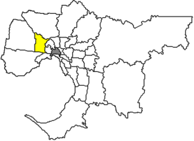
 Location of Brimbank City in Melbourne |
|
| structure | |
| State : |
|
| State : |
|
| Administrative headquarters: | Sunshine |
| Dates and numbers | |
| Area : | 123.4 km² |
| Residents : | 194,319 (2016) |
| Population density : | 1575 inhabitants per km² |
| Wards : | 4th |
Coordinates: 37 ° 47 ' S , 144 ° 50' O Brimbank City is a local government area (LGA) in the Australian state of Victoria . Brimbank belongs to the metropolis Melbourne , the capital of Victoria. The area is 123 km² and has around 194,000 inhabitants, making it the second largest city in the city.
Brimbank is located 10 to 20 km west of Melbourne city center and contains 25 neighborhoods: Albanvale , Albion, Ardeer , Cairnlea, Calder Park, Deer Park, Delahey, Derrimut , Kealba, Keilor, Keilor Downs, Keilor Lodge, Keilor North, Keilor Park , Kings Park, St Albans , Sunshine , Sunshine North, Sunshine West, Sydenham, Taylors Lakes and parts of Brooklyn, Hillside, Keilor East and Tullamarine . The seat of the City Council is in Sunshine in the southeast of the LGA.
55% of Brimbank's residents have moved here from abroad. One of Melbourne's largest industrial areas is located in the urban area, and the chemical industry is strongly represented here. Important facilities are the Sunshine Hospital and the St Albans Faculty of Victoria University .
administration
Brimbank City Council has eleven members elected by the residents of the four wards (Grasslands, Harvester and Taylors Ward three each, Horseshoe Bend two councilors). These four districts are determined independently of the districts. The mayor of the council is also recruited from among the councilors.
Web links
Individual evidence
- ↑ a b c Australian Bureau of Statistics : Brimbank (C) (Local Government Area) ( English ) In: 2016 Census QuickStats . June 27, 2017. Accessed June 10, 2018.