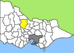
Loddon Shire
| Loddon Shire | |
 Location of the Loddon Shire in Victoria |
|
| structure | |
| State : |
|
| State : |
|
| Administrative headquarters: | Wedderburn |
| Dates and numbers | |
| Area : | 6,696.4 km² |
| Residents : | 7,516 (2016) |
| Population density : | 1.1 inhabitants per km² |
| Wards : | 4th |
Coordinates: 38 ° 25 ′ S , 143 ° 37 ′ E The Loddon Shire is a local government area (LGA) in the Australian state of Victoria . The area is 6696.4 km² and has about 7500 inhabitants.
Loddon is located in the north-central part of Victoria about 240 km northwest of the capital Melbourne and includes the following towns: Boort, Pyramid Hill, Serpentine, Dingee, Newbridge, Korong Vale, Wedderburn, Inglewood, Mitiamo, Bridgewater on Loddon and Tarnagulla. The seat of the City Council is in Wedderburn in the west of the LGA, a place with just 660 inhabitants.
The relatively large, sparsely populated area is mainly agricultural. 46% of all employees work in agriculture. Meat (sheep, beef), milk and cereals are the most important products of the region.
In addition, Loddon Shire can look back on a long gold digging past. Although the Shire is in a very productive region, the lack of water made gold mining difficult in many places, so that after the first discoveries in 1852 no larger permanent settlements emerged. A hundred years later, several large nuggets of up to 145 troy ounces (4.5 kg) were found in the Wedderburn area , and there are still many gold prospectors in the region today. The old gold rushes and mines often serve as tourist attractions.
administration
The Loddon Shire Council has five members elected by the residents of the four wards. Of these four districts, Boort, Terrick and Wedderburn have one council each, and Kooyoora two councilors. The mayor of the council is also recruited from among the councilors.
Web links
- Official site (English)
- Wedderburn - Homepage (English)
Individual evidence
- ↑ a b c Australian Bureau of Statistics : Loddon (S) ( English ) In: 2016 Census QuickStats . June 27, 2017. Retrieved May 12, 2020.
- ↑ Australian Bureau of Statistics : Wedderburn (L) ( English ) In: 2016 Census QuickStats . June 27, 2017. Retrieved May 12, 2020.