Mornington Peninsula Shire
| Shire of Mornington Peninsula | |
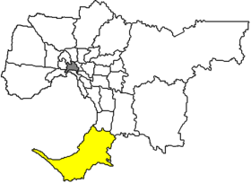
 Location of the Mornington Peninsula Shire in Melbourne |
|
| structure | |
| State : |
|
| State : |
|
| Administrative headquarters: | Rosebud |
| Dates and numbers | |
| Area : | 720 km² |
| Residents : | 154,999 (2016) |
| Population density : | 215 inhabitants per km² |
| Wards : | 11 |
Coordinates: 38 ° 21 ′ S , 144 ° 55 ′ E Mornington Peninsula Shire is a local government area (LGA) in the Australian state of Victoria . Mornington Peninsula is part of the Outer Metropolitan Area of Melbourne , the outer metropolitan area of the capital of Victoria. The area is 720 km² and has about 150,000 inhabitants.
Mornington Peninsula is 48 to 100 km from the city center and is the southernmost part of Melbourne. The peninsula also forms the southern end of Port Phillip Bay and separates it from Western Port Bay east of the Shire. It contains 37 districts and towns: Arthurs Seat, Balnarring, Balnarring Beach, Baxter, Bittern, Blairgowrie , Boneo, Cape Schanck, Crib Point, Dromana, Flinders, Hastings, HMAS Cerberus, McCrae, Main Ridge, Merricks, Merricks Beach, Merricks North , Moorooduc, Mornington, Mount Eliza, Mount Martha, Point Nepean, Point Leo, Portsea, Red Hill, Red Hill South, Rosebud, Rosebud West, Rye, Safety Beach, Shoreham, Somers, Somerville, Sorrento, Tootgarook and Tyabb. The Shire Council is based in Rosebud on the southern edge of Port Phillip Bay, which has a population of around 11,000.
In Sorrento, on the foothills of the peninsula, the first European settlement was founded in Victoria in 1803, but it was soon abandoned due to a lack of potable water.
Most of the Shire towns are lined up along the beach on Port Phillip Bay. Along the two bays and the Bass Strait , the peninsula has over 190 km of beach and is the leisure and local recreation area for Melbourne residents with extensive swimming and water sports. Portsea is very popular with scuba divers, Point Leo at Western Port and parts of the south coast are popular surfing areas, and Somers is home to one of the largest yacht clubs in Western Port Bay.
Cheviot Beach on the southwestern tip of the peninsula, Point Nepean in Portsea, gained notoriety. In December 1967, the then Australian Prime Minister Harold Holt disappeared without a trace while swimming in the strong current and had to be pronounced dead.
Arthurs Seat in the hinterland of Dromana , a 305 m high hill behind the coastal town, is a much-visited lookout point over the bay and the peninsula. Attractions include a chairlift over the hill, the longest in Victoria with a 40-minute drive, as well as several themed gardens and labyrinths.
Wine is also grown in the hilly interior of the peninsula. About 60 winemakers have settled here. Tyabb, also in the hinterland, is known for its numerous craft shops from blacksmiths and potters to tailors to painters and jewelers. Tyabb is also home to what is believed to be Australia's largest antique shop.
At the southernmost point of the Mornington Peninsula, Cape Schanck, is Victoria's second-oldest lighthouse after the Cape Otway tower . Together with the tower at Cape Wickham in the north of King Island , they form a triangle that is used by light and radio signals to navigate through Bass Strait .
At the southwest end of the Western Port is HMAS Cerberus, the largest training barracks in the Australian Navy, where around 6,000 recruits are trained annually, along with a public naval museum.
administration
The Mornington Peninsula Shire Council has eleven members who are elected by residents of the eleven Wards. These eleven districts (Balcombe, Cerberus, Kangerong, Mornington, Mount Eliza, Point Nepean, Red Hill, Rosebud, Rye, Truemans and Watsons) are determined independently of the districts. The mayor of the council is also recruited from among the councilors.
Town twinning
Web links
Individual evidence
- ↑ Australian Bureau of Statistics : Mornington Peninsula (S) (Local Government Area) ( English ) In: 2016 Census QuickStats . June 27, 2017. Accessed June 10, 2018.