West Wimmera Shire
| West Wimmera Shire | |
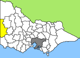
 Location West Wimmera Shire in Victoria |
|
| structure | |
| State : |
|
| State : |
|
| Administrative headquarters: | Edenhope |
| Dates and numbers | |
| Area : | 9,108.2 km² |
| Residents : | 4,251 (2016) |
| Population density : | 0.5 inhabitants per km² |
Coordinates: 37 ° 3 ' S , 141 ° 18' O West Wimmera Shire is a local government area ( Local Government Area ) in the Australian state of Victoria . The area is 9108.2 km² and with almost 3900 inhabitants by population, the second smallest LGA after the Queenscliffe Borough .
West Wimmera is located along Victoria's western border with South Australia and about 380 km from the capital Melbourne . It includes the following localities: Kaniva, Apsley, Edenhope, Douglas, Serviceton, Goroke, Chetwynd, Harrow and Dergholm. The seat of the City Council is in Edenhope in the southern half of the LGA with almost 700 inhabitants.
There are around 3,000 wetlands in the Shire , a quarter of all wetlands in Victoria, and numerous lakes, but they often do not have water all year round. In addition, the Little Desert National Park is located in the area, a 1,320 km² large, sandy and less fertile area, but which has a diverse flora and fauna.
West Wimmera lives from agriculture and sheep and cattle breeding or grain cultivation are the main sources of income in the region.
administration
The West Wimmera Shire Council has five members who are elected by LGA residents. West Wimmera is not divided into districts. The mayor of the council is also recruited from among the councilors.
Web links
Individual evidence
- ↑ a b Australian Bureau of Statistics : West Wimmera (S) ( English ) In: 2016 Census QuickStats . June 27, 2017. Retrieved May 13, 2020.
- ↑ Australian Bureau of Statistics : Edenhope (L) ( English ) In: 2016 Census QuickStats . June 27, 2017. Retrieved May 13, 2020.