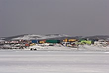
Davis station
Coordinates: 68 ° 34 ′ 36 ″ S , 77 ° 58 ′ 3 ″ E
The Davis Station is the southern Australian research station in the Antarctic . It is named after the Australian navigator and explorer John King Davis . The station is located 2250 nautical miles south-southwest of Perth on the Ingrid Christensen coast of Princess Elizabeth Land in the ice-free Vestfold Mountains . The 29 buildings were built on a rocky moraine and are only 100 m from the coast.
The ANARE station , which was set up on the occasion of the International Geophysical Year on January 12, 1957, is a key station in the network of Australian research stations and, with 70 people, accommodates the largest number of scientists during the summer season. As a rule, 22 researchers winter on this basis. The nearest Mawson station is 636 kilometers away .
The station's great research value depends on many factors; in particular, it is the basis for all scientific activities in the region. The station was not manned from December 1964 to January 1969.
Research focuses on observations of the ionosphere , meteorology , human and marine biology , and environmental research .
In June 2018, the Australian government approved money for the construction of a paved airstrip. This would be the first on the Antarctic continent.
Not far from the station is the Tarn station , a small freshwater lake .
Web links
- Official website of the Australian Antarctic Division (English)
- Official site of Davis Station (English)
- Webcam
- Davis Station 50th Anniversary ( Australian Government Antarctic Division )
- COMNAP Antarctic Facilities ( Memento of August 7, 2011 in the Internet Archive ) (English)
- COMNAP Antarctic Facilities Map (English)
Individual evidence
- ^ First permanent runway on the Antarctic continent. Fliegerrevue , June 14, 2018, accessed June 19, 2018 .
- ^ Station Tarn, Antarctica - Geographical Names, map, geographic coordinates. Retrieved January 19, 2020 .


