Ingrid Christensen Coast
| Ingrid Christensen Coast | ||
|---|---|---|
|
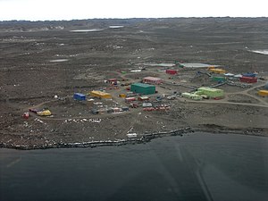
Coastline with Davis station
|
||
|
|
||
| location | Princess Elizabeth Land , East Antarctica | |
| Waters | Prydz Bay and Cooperation Lake ( Southern Ocean ) | |
| From |
Jennings Promontory 70 ° 10 ′ 0 ″ S , 72 ° 33 ′ 0 ″ E |
|
| To | western end of the West Ice Shelf 67 ° 30 ′ 0 ″ S , 81 ° 24 ′ 0 ″ E |
|
Coordinates: 70 ° S , 77 ° E
The Ingrid Christensen Coast ( Norwegian Ingrid Christensen Kyst ) is part of the Antarctic coast, which lies between the Jennings Promontory at 72 ° 33 'E and the western end of the West Ice Shelf at 81 ° 24' E. The coast is in the western part of Princess Elizabeth Land , east of the Amery Ice Shelf . Davis Station is also in this section .
They were discovered on February 20, 1935 by Captain Klarius Mikkelsen with the Norwegian whaler Torshavn . The coast was named after Ingrid Christensen, wife of whaling magnate Lars Christensen , the owner of the Torshavn. The southwestern part of the coast was discovered and photographed from the air during the US Navy - Operation Highjump in March 1947th
Individual evidence
- ^ Australian Antarctic Data Center Ingrid Christensen Coast
- ↑ antarctica-geography.findthedata.org ( page no longer available , search in web archives ) Info: The link was automatically marked as defective. Please check the link according to the instructions and then remove this notice. , Ingrid Christensen Coast, Antarctica

