Dair al-Balah
|
Dair al-Balah دير البلح דיר אל בלח |
||

|
||
|
||
| Administration : |
|
|
| Area: | Gaza Strip | |
| Governorate : | Gaza | |
| Coordinates : | 31 ° 25 ' N , 34 ° 21' E | |
| Height : | 15-18 m | |
| Area : | 27 km² | |
| Residents : | 67,727 (2014) | |
| Population density : | 2,508 inhabitants per km² | |
| Time zone : | UTC + 2 | |
| Telephone code : | (+970) 82532 | |
| Community type: | city | |
| Mayor : | Ahmad Al-kurd | |
|
|
||
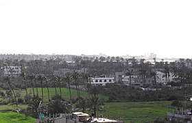
Dair al-Balah ( Arabic دير البلح, DMG Dayr al-Balaḥ ) is a Palestinian city in the Dair al-Balah Governorate , in the Gaza Strip . It is located 19 kilometers southwest of Gaza City and 1.5 kilometers from the Mediterranean coast. The city is home to the administration of the central region of the Gaza Strip. In 2006 the city had 49,751 inhabitants, since 2005 Hamas has held 13 of the 15 seats in the city parliament and thus also provides the mayor, Ahmad Kurd .
The city has been the target of Israeli military operations since 2001, most recently in Operation Cast Lead, on the grounds that it was the base for launching Qassam rockets against Israel.
In UNRWA - refugee camp Deir al-Balah 2014 8.009 people lived. Other refugee camps in the area around Dair al-Balah are:
- An Nuseirat refugee camp: 34,950 inhabitants
- Al Bureij refugee camp: 29,867 inhabitants
- Al Maghazi refugee camp: 19,998 inhabitants


