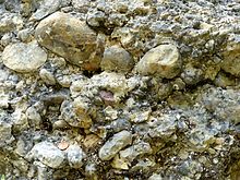
Dengelstein
The Dengel stone (also: Denkelstein ) forms with other boulders a boulder field in unincorporated Kempter Wald . After the erratic block in the Allgäu market Weiler-Simmerberg in the 18./19. Almost completely dismantled in the 19th century, the boulders mentioned here are the largest in Germany.
description
With a height of over 8 meters, a volume of approx. 1400 cubic meters and a weight of 3700 tons, the Dengelstein is one of the largest surviving boulders in the Kemptner Forest. During the high glacial period around 18,000 years ago, it was probably transported through the Iller glacier from the Rottachberg to the Alpine foothills.
It consists of a tertiary conglomerate of the bunk layers . However, it is just one boulder among thousands that form the largest known boulder distribution in the northern Eastern Alps between Rottachberg and Kraftisried in the Allgäu.
In the times of the Celts , horses are said to have been sacrificed in the fire on Dengelstein, which means that Dengelstein is also important as a prehistoric place of worship . The area around the Dengelstein was called Keltenstein in the Alemannic times .
There are several legends about the Dengelstein. So the devil should knock his scythe on the Dengelstein when evil is about to happen to people. Another legend tells that the malicious wife of a farmer was trapped in the stone and had to knock her scythe there. Both legends can be read in full on display boards near the stone.
The iron construction around the Dengelstein is a work of art from 1997.
The legend of the Dengelstein appears in the second volume of the novel series Kommissar Kluftinger .
Access
The Dengelstein is freely accessible. The walk from the village of Betzenried is about 1.5 km.
Geotope
The boulder is designated by the Bavarian State Office for the Environment as geotope 780R018. The geotope is also one of the 100 most beautiful geotopes in Bavaria . See also the list of geotopes in the Oberallgäu district .
Boulder field
Investigations have shown that the Dengelstein, although by far the best-known of the boulders in the Kempter Forest area, is only the fourth largest of the boulder field deposited here.
Bigger than him are:
- The "stone" (location: ⊙ ) near the hamlet of Stein, - broken down into four parts, originally probably about 25 × 20 × 11 m, about 3300 m³ (8580 t)
- The "Baltenstein" (location: ⊙ ) near Betzigau, - dismantled into three parts, originally probably approx. 23 × 15 × 11 m, approx. 2277 m³ (5920 t)
- The "Beilstein" ("Beichelstein") (location: ⊙ ) near Görisried, - two stones, the larger one approx. 20 × 15 × 11 m, approx. 1980 m³ (5148 t)
The bursting of the blocks is attributed to natural causes during the melting of the glaciers.
Individual evidence
- ↑ a b c d e Müller, Scholz: News on the erratic boulder field of…. P. 103.
- ^ According to the board on site, a work by Osse Müller with the name Gemarkungszeichen
- ↑ Geotop: Findling Dengelstein (accessed on October 12, 2013; PDF; 227 kB)
- ↑ Dengelstein (accessed October 12, 2013)
- ↑ Müller, Scholz: News about the erratic boulder field of…. P. 104.
literature
- Müller, Martin and Scholz, Herbert: News about the erratic boulder field in the Kempter Forest in the Allgäu . In: Natural Science Association for Swabia e. V. (Hrsg.): Reports of the Natural Science Association for Swabia . tape 115 , 2011, ISSN 0720-3705 , p. 95–127 ( geo.uni-augsburg.de [PDF; accessed on December 17, 2013]).
Web links
Coordinates: 47 ° 42 ′ 37 ″ N , 10 ° 24 ′ 22 ″ E


