Dhupgarh
| Dhupgarh | ||
|---|---|---|
|
Mountain landscape near Pachmarhi |
||
| height | 1350 m | |
| location | Madhya Pradesh State , India | |
| Mountains | Satpura Mountains | |
| Coordinates | 22 ° 26 '57 " N , 78 ° 22' 18" E | |
|
|
||
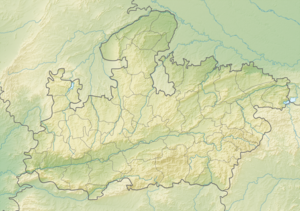
The Dhupgarh or Dhoop Garh ( Hindi धूपगढ़ ) is an approx. 1350 m high mountain peak in the Satpura Mountains in the district of Hoshangabad in the Indian state of Madhya Pradesh ; it is the highest mountain in central India.
location
The Dhupgarh is located roughly in the middle of the Satpura chain, which runs from east to west, approx. 180 km (driving distance) southeast of the megacity of Bhopal and approx. 260 km southwest of Jabalpur . Pachmarhi (approx. 10 km to the east), which is open to tourists and located approx. 1060 m above sea level, is usually the starting point for summit tours.
Rivers
The northern flank of the Satpura Mountains, which is rather rainy by Indian standards (up to 2000 mm / year), is drained by smaller streams and rivers, the water of which is taken up by the Tawa River and ultimately by the Narmada and channeled into the Arabian Sea in the state of Gujarat .
nature
The Dhupgarh is roughly the geographic center of the approximately 1400 km² Satpura National Park with its exotic animals and plants.

