Dolgener See (Feldberger Seenlandschaft)
| Dolgener lake | ||
|---|---|---|
| Geographical location | District of Mecklenburg Lake District | |
| Tributaries | many smaller tributaries | |
| Drain | Godendorfer Mühlenbach → Havel | |
| Location close to the shore | Dolgen , Lüttenhagen, Koldenhof | |
| Data | ||
| Coordinates | 53 ° 20 '23 " N , 13 ° 21' 21" E | |
|
|
||
| Altitude above sea level | 97.8 m above sea level NHN | |
| surface | 0.69 km² | |
| volume | 6,840,000 m³ | |
| Maximum depth | 27.5 m | |
| Middle deep | 10.06 m | |

|
||
| The Dolgener See as a source lake of the Godendorfer Mühlenbach-Hegensteinfließ | ||
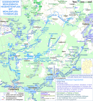
The Dolgener See in the Mecklenburg Lake District is - of the rivulets and ditches that feed it, the one that flows out at the northeastern end of the lake is classified as a source stream - the source lake of the Godendorfer Mühlenbach , which finally becomes the size of a river in Brandenburg and as the Hegensteinfließ at Fürstenberg into the Schwedtsee of the Havel flows out. The Dolgener See is 4–5 km west of Feldberg , the capital of the Feldberger Seenlandschaft community , in the Feldberger Seenlandschaft nature park .
It is a glacial tongue basin lake, embedded in a terminal moraine area . It has an approximate length of around 4.2 kilometers and an approximate width of only 200 meters. The very narrow and slightly sickle-shaped lake is poorly structured. In the south it has almost north-south direction, in the north almost east-west direction. At 97.6 m above sea level , the lake is one of the highest lakes in Mecklenburg-Western Pomerania, but the Woldegker Stadtsee is nine and the Bucheisensee a good 30 m higher. The surrounding heights reach 128 m above sea level. NHN not far from the east bank. There are three villages near the lake. These are Dolgen in the west, Lüttenhagen in the east and Koldenhof in the southwest. The Koldenhof sawmill is located at the southern tip. The southern part and large parts of the east bank are forested, the rest is used for agriculture. The disused Thurow – Feldberg railway runs north of the lake .
Surname
The name Dolgener See is derived from the Old Slavic word dlŭgŭ for long , which, however, was transferred to the place Dolgen northwest of the lake centuries ago (as with Dolgen am See / Dolgener See in the Rostock district ).
