
Godendorfer Mühlenbach-Hegensteinfließ
|
Godendorfer Mühlenbach, Hegensteinfließ |
||
 Brückentinsee in the course of the tributary Thymenfließ |
||
| Data | ||
| Water code | DE : 58118 | |
| location | Mecklenburg-Western Pomerania a . Brandenburg , Germany | |
| River system | Elbe | |
| Drain over | Havel → Elbe → North Sea | |
| source | northeast Inflow of the Dolgen lake 53 ° 21 ′ 1 ″ N , 13 ° 23 ′ 26 ″ E |
|
| Source height | 98 m | |
| muzzle | in the Schwedtsee of the Havel Coordinates: 53 ° 11 '26 " N , 13 ° 8' 48" E 53 ° 11 '26 " N , 13 ° 8' 48" E |
|
| Mouth height | 51.9 m | |
| Height difference | 46.1 m | |
| Bottom slope | 1.1 ‰ | |
| length | 41.4 km | |
| Catchment area | 210 km² | |
| Left tributaries | Thyme flow | |
| Right tributaries | Digging out of Keetzseen | |
| Flowing lakes | Dolgener See , Godendorfer See , Dabelowsee , Thymensee | |
Godendorfer Mühlebach is Mecklenburg , Hegen Stone flow of Brandenburg Name of 41.39 km long Havel inflow to the GKZ 58,118th
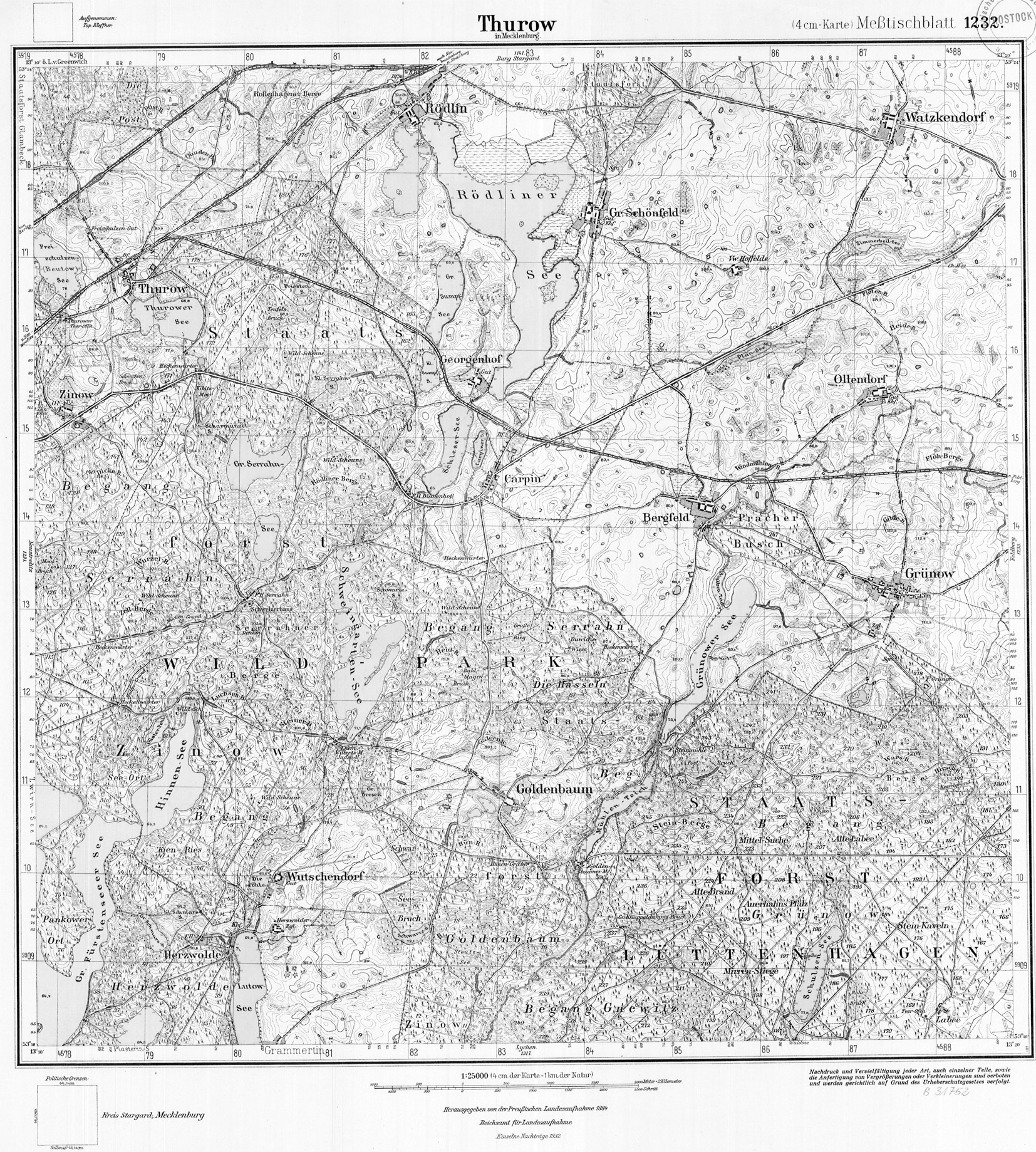
Nowadays, the source stream is a body of water that is slightly more than 400 m long and has been straightened to a high degree and flows into the northeast end of the Dolgener See west of Feldberg in the Mecklenburg Lake District in Mecklenburg-Western Pomerania , 98 m above sea level. The brook leaves the 4.036 km long but narrow lake around the middle of the west bank. In its further course it flows through several natural and artificial lakes. Its largest tributary, the river code 5811878, flows into its, the Thymensee , and is called Thymenfließ in Brandenburg and Mühlenfließ in Mecklenburg.
From the middle of the Grünower See to below the Goldenbaumer Mühle, the Godendorfer Mühlenbach Bach flows through the exclave of the Müritz National Park east of Neustrelitz , in which the source lake of the Mühlenfließ is also located.
From the eastern basin of Lake Godendorfer See , a cross-connection to the Thymenfließ branches off to the south, which ends there as a mosquito trap.
As can be seen from the short distances and clear height differences, the Schliesee and Sägersee served as mill ponds for a long time.
From the Schliesee to the Großer Schwaberowsee the body of water 58118 is also called Schwaberowbach. When entering this lake it passes the national border.
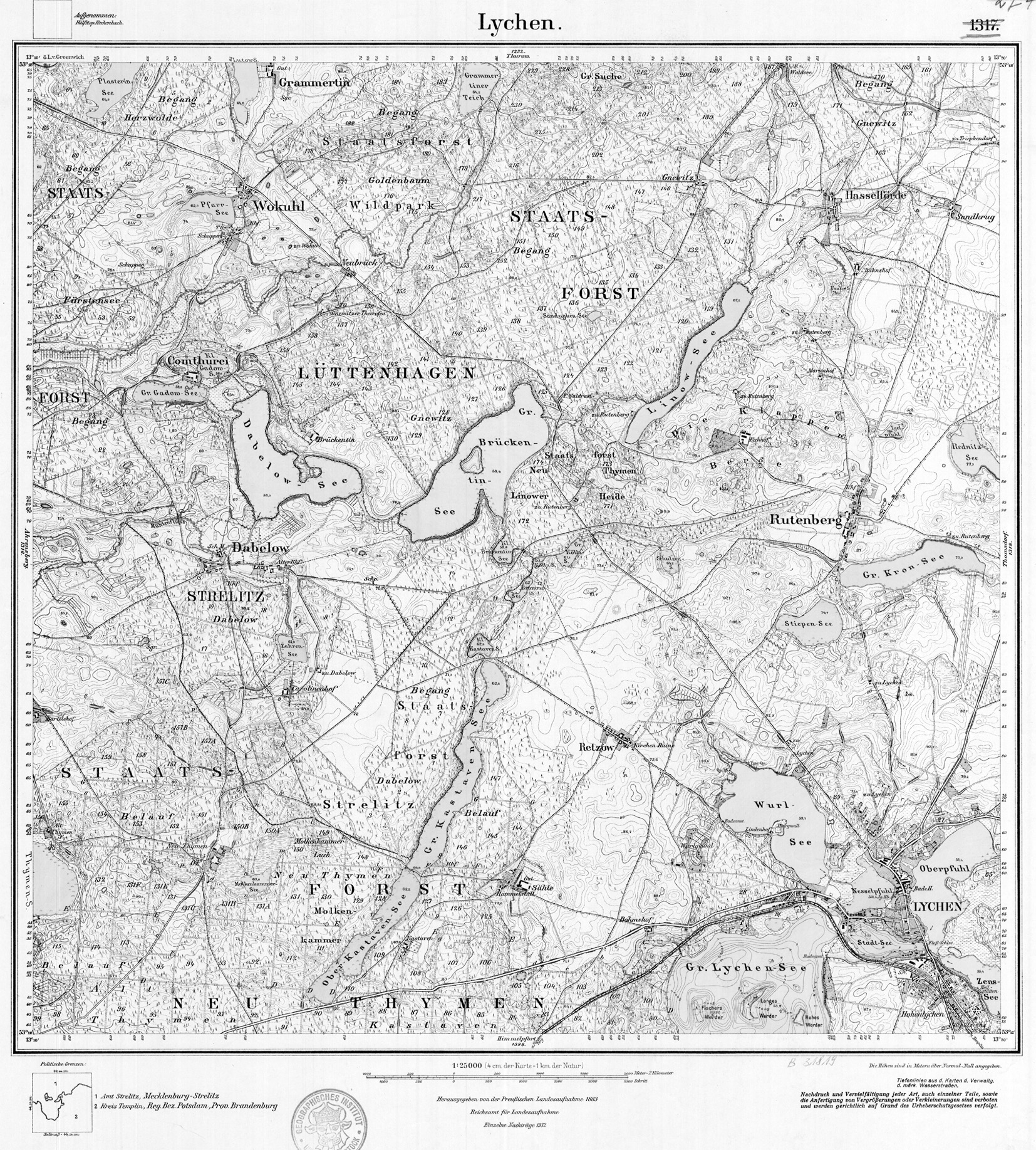
In Fürstenberg / Havel the Hegensteinfließ, also called Hegensteinbach or Thymenbach from Lake Thymensee, flows north of the city center into the west bank of the Schwedtsee .

Lakes and tributaries
Notes on the representation:
- The table of lakes and tributaries is arranged upstream.
- Distances from the mouth into the Havel are marked with III, distances from downstream mouths with correspondingly higher Roman numerals .
- Where a tributary reaches the larger flowing water in a lake, the stationing point is indicated on the water axis plus the distance of the mouth on the lake shore from this point.
| page | Surname | GKZ | km from the estuary |
Height [m] above NHN |
Area or length |
annotation | |
| Schwedtsee ( Havel ) | II: ... + 0.7 | 51.9 (hist.) | 0.51 km² | ||||
| Thyme lake | 5811879 | III: 3.312-6.51 | 52.8 (hist.) | 1.11 km² | |||
| Left | Thymenfließ = (Dabelower) mill flow | 5811878 | III: 4.4 + 0.145 | 20.7 km | in the Thyme Lake | ||
| right | Trench from Godendorf = L070 = mosquito trench |
581187896 | IV: 4.23 | 2,755 km | from the Godendorfer See (see below) | ||
| ↑ Dabelowsee | 581187879 | IV: 8.375-9.95 | 59.7 | 1.001 km² | |||
| right | Graben ← Great Gadowsee | 5811878741 | 59.9 | 0.147 km² | in the Dabelowsee | ||
| right | Graben ← Little Gadowsee | 5811878721 | 59.9 | 0.089 km² | in the Dabelowsee | ||
| ↑ Great Brückentinsee | 581187859 | IV: 10.40-13.43 | 59.8 | 1.296 km² | |||
| Left | Schulzenseegraben | 581187854 | IV: 11.5 + 0.5 | 3.80 km | in the Großer Brückentinsee | ||
| ↑ Kleiner Brückentinsee | V: 0.33-0.53 | 61.1 (1932) | 0.066 km² | ||||
| ↑ Little Köllnsee | V: 0.81-94 | 61.1 (1932) | 0.011 km² | ||||
| ↑ Great Köllnsee | V: 1.22-1.46 | 58.0 (1932) | 0.051 km² | ||||
| ↑ Schulzensee (near Rutenberg) | V: 2.56-2.66 | 64.2 (1932) | 0.037 km² | ||||
| ↑ Linowsee | IV: 14.7-15.91 | 67.2 (1932) | 0.487 km² | ||||
| Left | Graben from Triepkendorf | 581187832 | IV: 17.8 + 0.11 | 5.116 km | rear end of the Linowsee | ||
| ↑ Schulzensee (near Waldsee) | 581187811 | IV: 19.5-20.11 | 77.6 | 0.198 km² | Waldsee homestead | ||
| ↑ Great Schwaberowsee | III: 7.77-8.32 | 54 (1881) | 0.067 km² | ||||
| right | Digging from the Crooked Lake | 5811854 | III: 8.15 + 0.79 | 1.15 km | in the great Schwaberowsee | ||
| ↑ Little Schwaberowsee | 58118549 | IV: 0.3 | 64.3 | 0.67 km² | |||
| ^ Krummer See | 58118541 | IV: 1.15 | 56.4 | 0.081 km² | |||
| right | Graben ← Schulzensee (Godendorf) | 5811855 | - | 0.02 km² | |||
| ↑ Röthsee | 5811852 | 57.3 | 0.13 km² | ||||
| ↑ Sägersee | 58118539 | III: 9.55-9.9 | 56.0 | 0.046 km² | |||
| ↑ Schliesee | 5811851 | III: 10.14-10.38 | 57.6 | 0.052 km² | Godendorfer paper mill | ||
| ↑ Godendorfer See | 58118399 | III: 10.77-12.4 | 57.8 | 0.50 km² | 2 basins | ||
| right | Dig from ... Keetzsee (n) | 58118398 | III: 10.85 + 0.29 | 5.23 km | lower basin of the Godendorfer See | ||
| ↑ Rohrpöhle | 581183985 | IV: 1.08-1.18 u. 1.32-1.49 |
60 | 0.27 km² | 2 tube piles | ||
| ↑ Great Keetzsee | 5811839839 | IV: 1.94-2.07 | 61.8 | 0.43 km² | |||
| ↑ Little Keetzsee | 581183981 | IV: 3.06-3.48 | 62.0 | 0.29 km² | |||
| ⇒ LEFT | Trench from Godendorf = L070 = mosquito trench |
581187896 | III: 12.1 + 0.29 | 57.8 | 2,755 km | upper basin of the Godendorfer See | |
| right | Trench from Wokuhl | 58118394 | III: 17.16 | 62 | 1.55 km | ||
| ↑ Pfarrsee | 581183941 | IV: 1.55 | 62.8 | 0.12 km² | Wokuhl-Dabelow | ||
| ↑ Grammentiner pond | 58118391 | III: 21.9-22.37 | 65.7 | 1.57 km² | |||
| ↑ (Goldenbaumer) mill pond | III: 35.3.3-26.66 | 71.3 | 0.152 km² | ||||
| ↑ Grünower See incl. Stubbenteich | 58118339 | III: 27.16-29.24 | 75.2 | 0.462 km² | |||
| ↑ Dolgener See | 58118119 | III: 36.37-40.95 | 97.6 | 0.695 km² | |||
| ↑ source | III: 41.39 | 98 | |||||
Individual evidence
- ↑ a b c d GAIA-MV: Height query in terrain MV
- ↑ Hist. Measuring table sheets in the Brandenburg viewer
- ↑ a b Map portal environment Mecklenburg-Western Pomerania
- ↑ Geoportal Brandenburg → Water data (ZIP) → u. a. PDF: River directory, source data set gewnet25 Version 4.2
- ↑ Eva Driescher: Changes in waters in historical time - A study in sub-areas of the districts of Neubrandenburg and Potsdam (dissertation 1974, PDF of the state environmental agency brandenburg 2003)
Web links
- Geoportal GAIA MV
- Brandenburg viewer
- Lake profiles of the state of Brandenburg
- Geogreif - Geographical collections of the University of Greifswald
- Jürgen Kniesz: Watermills in the Havel catchment area between Neustrelitz and Feldberg in New Contributions to Natural Space and Landscape History in the Serrahn Sub-Area of the Müritz National Park (PDF) , p. 63 ff.