
Saint-Arcons-d'Allier
| Saint-Arcons-d'Allier | ||
|---|---|---|
|
||
| region | Auvergne-Rhône-Alpes | |
| Department | Haute Loire | |
| Arrondissement | Brioude | |
| Canton | Gorges de l'Allier-Gévaudan | |
| Community association | Rives du Haut Allier | |
| Coordinates | 45 ° 5 ' N , 3 ° 33' E | |
| height | 498–1,045 m | |
| surface | 16.08 km 2 | |
| Residents | 189 (January 1, 2017) | |
| Population density | 12 inhabitants / km 2 | |
| Post Code | 43300 | |
| INSEE code | 43167 | |
_001_6.jpg) View of Saint-Arcons-d'Allier |
||

Saint-Arcons-d'Allier is a French municipality with 189 inhabitants (at January 1, 2017) in the Haute-Loire in the region Auvergne Rhône-Alpes (before 2016 Auvergne ). It belongs to the Arrondissement of Brioude and the canton of Gorges de l'Allier-Gévaudan (until 2015 Langeac ).
geography
Saint-Arcons-d'Allier is located about thirty kilometers west-northwest of Le Puy-en-Velay on the Allier . Neighboring municipalities of Saint-Arcons-d'Allier are Mazeyrat-d'Allier in the north and north-west, Vissac-Auteyrac in the north-east, Siaugues-Sainte-Marie in the east, Saint-Julien-des-Chazes in the south, Chanteuges in the west and Langeac in the Northwest.
Population development
| year | 1962 | 1968 | 1975 | 1982 | 1990 | 1999 | 2006 | 2011 | 2016 |
|---|---|---|---|---|---|---|---|---|---|
| Residents | 329 | 279 | 245 | 203 | 187 | 164 | 180 | 198 | 195 |
| Source: Cassini and INSEE | |||||||||
Attractions
- Saint-Loup church, a historic monument since 1980
- Priory and castle ruins, since 1986

Saint-Loup church
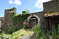
Priory and castle ruins


Web links
Commons : Saint-Arcons-d'Allier - Collection of images, videos and audio files