Azerat
| Azerat | ||
|---|---|---|
|
|
||
| region | Nouvelle-Aquitaine | |
| Department | Dordogne | |
| Arrondissement | Sarlat-la-Canéda | |
| Canton | Haut-Périgord Noir | |
| Community association | Terrassonnais en Périgord Noir Thenon Hautefort | |
| Coordinates | 45 ° 9 ′ N , 1 ° 7 ′ E | |
| height | 128-317 m | |
| surface | 20.05 km 2 | |
| Residents | 442 (January 1, 2017) | |
| Population density | 22 inhabitants / km 2 | |
| Post Code | 24210 | |
| INSEE code | 24019 | |
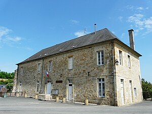
 Mairie Azerat |
||
Azerat is a French commune with 442 inhabitants (as of January 1, 2017) in the Dordogne department in Nouvelle-Aquitaine . It belongs to the arrondissement of Sarlat-la-Canéda and to the Haut-Périgord Noir, which has existed since 2015 . The residents call themselves Azeracois .
geography
Neighboring municipalities are Sainte-Orse in the northwest, Saint-Rabier in the northeast, La Bachellerie in the southeast, Auriac-du-Périgord in the south, Thenon in the southwest and Ajat in the west. The nearest train stations are in Thenon and Saint-Rabier. North of the village center there is a railway line as well as the Route nationale 89 .
Population development
| year | 1962 | 1968 | 1975 | 1982 | 1990 | 1999 | 2008 | 2013 |
|---|---|---|---|---|---|---|---|---|
| Residents | 509 | 495 | 454 | 419 | 407 | 409 | 424 | 437 |
| Source: Cassini and INSEE | ||||||||
Attractions
- Notre-Dame-de-Bonne-Espérance chapel , Monument historique
- Saint Martin Church
- War memorial
Web links
Commons : Azerat - collection of images, videos and audio files


