
Vals-le-Chastel
| Vals-le-Chastel | ||
|---|---|---|
|
||
| region | Auvergne-Rhône-Alpes | |
| Department | Haute Loire | |
| Arrondissement | Brioude | |
| Canton | Pays de Lafayette | |
| Community association | Rives du Haut Allier | |
| Coordinates | 45 ° 16 ′ N , 3 ° 31 ′ E | |
| height | 507-777 m | |
| surface | 3.99 km 2 | |
| Residents | 44 (January 1, 2017) | |
| Population density | 11 inhabitants / km 2 | |
| Post Code | 43230 | |
| INSEE code | 43250 | |
 View of Vals-le-Chastel |
||

Vals-le-Chastel ( identical in Occitan ) is a French commune with 44 inhabitants (as of January 1, 2017). It is located in the department of Haute-Loire in the region Auvergne Rhône-Alpes (before 2016 Auvergne ) and belongs to Arrondissement Brioude and the Canton Pays de Lafayette (2015 Paulhaguet ).
geography
Vals-le-Chastel is located about 39 kilometers northwest of Le Puy-en-Velay on the banks of the Doulon River . Vals-le-Chastel is surrounded by the neighboring communities of Frugières-le-Pin in the north and west, Saint-Didier-sur-Doulon in the north and east, Montclard in the east and Saint-Préjet-Armandon in the south and south-east.
Population development
| year | 1962 | 1968 | 1975 | 1982 | 1990 | 1999 | 2006 | 2011 | 2016 |
| Residents | 66 | 63 | 62 | 46 | 44 | 46 | 50 | 44 | 44 |
| Source: Cassini and INSEE | |||||||||
Attractions
- Saint-Paul church from the 15th century, monument historique since 1962
- Notre-Dame-des-Anges chapel, Monument historique since 1971
- 15th century castle
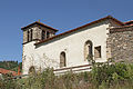
Saint Paul Church
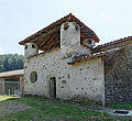
Notre-Dame-des-Anges chapel


Web links
Commons : Vals-le-Chastel - collection of images, videos and audio files