
Lempdes-sur-Allagnon
| Lempdes-sur-Allagnon | ||
|---|---|---|

|
|
|
| region | Auvergne-Rhône-Alpes | |
| Department | Haute Loire | |
| Arrondissement | Brioude | |
| Canton | Sainte-Florine | |
| Community association | Auzon Community | |
| Coordinates | 45 ° 23 ' N , 3 ° 16' E | |
| height | 425-546 m | |
| surface | 10.4 km 2 | |
| Residents | 1,342 (January 1, 2017) | |
| Population density | 129 inhabitants / km 2 | |
| Post Code | 43410 | |
| INSEE code | 43120 | |
 Aerial view of Lempdes-sur-Allagnon |
||

Lempdes-sur-Allagnon ( Occitan : loin ) is a French municipality with 1342 inhabitants (as of January 1 2017) in the department of Haute-Loire in the region Auvergne Rhône-Alpes . It is located in the Arrondissement of Brioude and in the Canton of Sainte-Florine (until 2015: Canton of Auzon ).
geography
Lempdes-sur-Allagnon is located about 46 kilometers south-southeast of Clermont-Ferrand on the Alagnon River . Lempdes-sur-Allagnon is surrounded by the neighboring communities of Moriat in the north, Sainte-Florine in the northeast, Vergongheon in the east, Bournoncle-Saint-Pierre in the southeast, Saint-Géron in the south, Léotoing in the west and southwest and Chambezon in the west.
The A75 autoroute and the national route 102 run through the municipality .
Population development
| year | 1962 | 1968 | 1975 | 1982 | 1990 | 1999 | 2006 | 2013 |
| Residents | 1,445 | 1,583 | 1,526 | 1,510 | 1,403 | 1,371 | 1,318 | 1,326 |
| Source: Cassini and INSEE | ||||||||
Attractions
- Romanesque church of Saint-Géraud from the 11th century
- Market hall
- lock

Saint-Géraud church
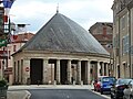
Market hall


Personalities
- Léonce Lagarde (1860–1936), diplomat