
Chanteuges
| Chanteuges | ||
|---|---|---|
|
||
| region | Auvergne-Rhône-Alpes | |
| Department | Haute Loire | |
| Arrondissement | Brioude | |
| Canton | Gorges de l'Allier-Gévaudan | |
| Community association | Communauté de communes des Pays de Cayres et de Pradelles | |
| Coordinates | 45 ° 4 ′ N , 3 ° 32 ′ E | |
| height | 493-894 m | |
| surface | 16.33 km 2 | |
| Residents | 441 (January 1, 2017) | |
| Population density | 27 inhabitants / km 2 | |
| Post Code | 43300 | |
| INSEE code | 43056 | |
 View of Chanteuges |
||

Chanteuges is a French municipality with 441 inhabitants (at January 1, 2017) in the Haute-Loire in the region Auvergne Rhône-Alpes (before 2016 Auvergne ). It belongs to the Arrondissement of Brioude and the canton of Gorges de l'Allier-Gévaudan (until 2015 Langeac ). The inhabitants are called Chanteugeois .
geography
Chanteuges is located about 29 kilometers west-northwest of Le Puy-en-Velay on the Allier River and its tributary Desges . Neighboring municipalities of Chanteuges are Langeac in the north and west, Saint-Arcons-d'Allier in the east and northeast, Saint-Julien-des-Chazes in the southeast and Pébrac in the south.
Population development
| year | 1962 | 1968 | 1975 | 1982 | 1990 | 1999 | 2006 | 2011 | 2016 |
|---|---|---|---|---|---|---|---|---|---|
| Residents | 512 | 454 | 358 | 348 | 376 | 403 | 411 | 436 | 448 |
| Source: Cassini and INSEE | |||||||||
Attractions
- Priory of Chanteuges with the Church of Saint-Marcellin (also: Saint-Saturnin), Monument historique from 1840
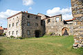
Priory

Saint-Marcellin church


Web links
Commons : Chanteuges - collection of images, videos and audio files