Sainte-Florine
| Sainte-Florine | ||
|---|---|---|
|
|
||
| region | Auvergne-Rhône-Alpes | |
| Department | Haute Loire | |
| Arrondissement | Brioude | |
| Canton | Sainte-Florine (main town) | |
| Community association | Auzon Community | |
| Coordinates | 45 ° 24 ' N , 3 ° 19' E | |
| height | 400-511 m | |
| surface | 7.67 km 2 | |
| Residents | 3,154 (January 1, 2017) | |
| Population density | 411 inhabitants / km 2 | |
| Post Code | 43250 | |
| INSEE code | 43185 | |
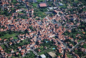
 View of Sainte-Florine |
||
Sainte-Florine is a French municipality with 3154 inhabitants (as of January 1 2017) in the department of Haute-Loire in the region Auvergne Rhône-Alpes . It is located in the Arrondissement of Brioude and in the canton of Sainte-Florine . The inhabitants are called Florinois (es) .
geography
Sainte-Florine is located between the Alagnon and Allier rivers . Sainte-Florine is surrounded by the neighboring communities of Brassac-les-Mines in the north and northeast, Vézézoux in the east, Vergonghen in the southeast, Frugerès-les-Mines in the south, Lempdes-sur-Allagnon in the southwest, Moriat in the west and Charbonnier-les- Mines in the northwest.
The Cevennenbahn stops here.
history
The villa of Seveirag from the first century has been handed down from antiquity. In 1151 a convent was founded here.
Population development
| year | 1962 | 1968 | 1975 | 1982 | 1990 | 1999 | 2006 | 2011 |
| Residents | 3,291 | 3,625 | 3,673 | 3,335 | 3,021 | 3,002 | 3,105 | 3,096 |
Attractions
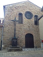
- Saint-Jacques church from 1641 with modifications in the 17th and 19th centuries
- Chapel Sainte-Florine from 1740 with the relics of the saints from the 4th and 6th centuries
- 15th century tower
Parish partnership
There is a partnership with the district of Triebes in the town of Zeulenroda-Triebes in Thuringia .

