
Agnat (Haute-Loire)
| Agnate | ||
|---|---|---|
|
||
| region | Auvergne-Rhône-Alpes | |
| Department | Haute Loire | |
| Arrondissement | Brioude | |
| Canton | Sainte-Florine | |
| Community association | Brioude Sud Auvergne | |
| Coordinates | 45 ° 21 ′ N , 3 ° 27 ′ E | |
| height | 445-860 m | |
| surface | 19.65 km 2 | |
| Residents | 187 (January 1, 2017) | |
| Population density | 10 inhabitants / km 2 | |
| Post Code | 43100 | |
| INSEE code | 43001 | |
 City Hall (Mairie) of Agnat |
||

Agnat ( Occitan identical) is a French municipality with 187 inhabitants (as of January 1 2017) in the department of Haute-Loire in the region Auvergne Rhône-Alpes . It is located in the Arrondissement of Brioude and in the Canton of Sainte-Florine (until 2015: Canton of Auzon ). The inhabitants are called Agnatois .
geography
Agnat is about 56 kilometers south-southeast of Clermont-Ferrand . Agnat is surrounded by the neighboring communities of Saint-Hilaire in the north, Champagnac-le-Vieux in the east, Chaniat in the southeast, Lamothe in the south and southwest and Azérat in the west.
Population development
| year | 1962 | 1968 | 1975 | 1982 | 1990 | 1999 | 2006 | 2013 |
| Residents | 353 | 316 | 302 | 251 | 222 | 209 | 190 | 189 |
| Source: Cassini and INSEE | ||||||||
Attractions
- Saint-Julien-l'Hospitalier church from the 12th century with additions from the 15th and 16th centuries, Monument historique
- Les Grèzes Castle
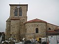
Saint-Julien-l'Hospitalier church

Les Grèzes Castle


Personalities
- Jules-Joseph Moury (1873–1935), missionary, Apostolic Prefect / Vicar of the Ivory Coast (1910–1935)
Web links
Commons : Agnat - collection of images, videos and audio files