
Dolmen de la Pierre Levée (Linez)

The Dolmen de la Pierre Levée (German: The raised rock ), also called Allée couverte de la Pierre Levée , is one of the largest Neolithic megalithic structures in the Berry and the largest in the Indre department in France . It is located in the village of Liniez , around 400 m north of the town exit on the edge of a field around 25 m to the right (east) of the D 926 road to Vatan and is the private property of the landowner.
In France, dolmen is the generic term for Neolithic megalithic structures of all kinds (see: French nomenclature ). The dolmen has been registered and protected as a Monument historique since 1927 .
description
- Dolmen de la Pierre Levée

View from the northwest

View from the west
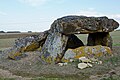
View from the southwest


The dolmen, roughly aligned from east to west, is about 10.0 m long and up to 5.7 m wide and has the shape of an elongated chamber that narrows at the top. It basically consists of three parts, the entrance in the east, an antechamber and the actual chamber, the best preserved part of the complex. It was once probably covered with four capstones, three of which are still in different positions: one at the rear end, still horizontally on the orthostats (supporting stones), one in an inclined position in the middle and one lying flat on the ground at the front end . A number of bearing stones are still present, as well as the back end stone and there are signs of a partition inside, which could also be the remains of a broken cap stone. The various slabs and supporting stones have an average thickness of 60 cm.
The chamber consists of a 3.0 m long and up to 2.2 m wide, roughly rectangular cover plate, which rests on two supporting stones with an average height of 1.6 m. The vertical, 2.6 m long stone that closes the grave chamber in the west only protrudes about 80 cm from the ground, so that an 80 cm high "window" opens between it and the cover plate. The rest of the dolmen has partially collapsed. In the east, on the entrance side, the cover plate rests on two supporting stones. This plate is about 3.7 m wide and 2.0 m long. There are more stones between the anteroom and the chamber, some of which have overturned. In this area there is another 2.0 m wide and 3.5 m long ceiling slab. This slab slipped from its northern bearing stones and broke in the process. The arrangement of the remaining orthostats and cover plates indicates that there was once at least one additional cover plate in the area of the antechamber.
The dolmen was excavated by Ludovic Martinet in 1875 and 1876. He found the interior filled with objects that indicated a long-term use of the living space in different periods. In the rear chamber, Martinet found a paving of flat stones at a depth of 1.3 m and on top of it, along the walls and covered with flat stones, various bones of five people, including a 25-year-old woman, a very old man and a 40 or so woman Years old man. The latter's skull was damaged by either a drilling or a violent blow. Smaller panels were found that might have belonged to a partition.
Martinet also found evidence of the existence of a former burial mound , which, however, had almost completely disappeared. The dolmen with its completely above-ground stone structure was covered by a mound of rubble and earth to stabilize the stone structure.
Adjacent tumulus
Almost 1.5 km further north on the map of the IGN on the left of the road D 926 north of the ponds and immediately north of the path to “Les Michots” there is a tumulus elliptique (“elliptical tumulus”). It is not known whether there is a dolmen underneath.
Footnotes
- ↑ There are a number of dolmens in France called La Pierre Levée .
- ↑ Dolmen Liniez in the Base Mérimée of the French Ministry of Culture (French)
- ↑ Dolmen Liniez in the Base Mérimée of the French Ministry of Culture (French)
- ↑ Dolmen Liniez in the Base Mérimée of the French Ministry of Culture (French)
- ^ Institut National de l'Information Géographique et Forestière
Web links
- Dolmen Liniez in the Base Mérimée of the French Ministry of Culture (French)
- Le dolmen de la Pierre Levée (French)
- Le plus grand dolmen de l'Indre: La Pierre levée à Liniez (French)
- Short video of the dolmen
Coordinates: 47 ° 1 ′ 39.5 ″ N , 1 ° 45 ′ 30.5 ″ E