
Danube Park (Regensburg)
| Danube Park Westpark |
|
|---|---|
|
|
|

|
|
| Bathing bay on the Danube | |
| Basic data | |
| place | regensburg |
| Created | 1960s |
| Buildings | Westbad |
| use | |
| Park design | Modern landscape park |
| Technical specifications | |
| Parking area | 65 ha |

The Donaupark , also known as Westpark , is located in the western part of Regensburg and is the largest park in the city .
geography
The Donaupark is located at the northernmost point of the Danube and stretches for almost 2.5 km from the Schillerwiesen in the east near the Herzogspark on the edge of the old town of Regensburg, along the Danube to the west, to the urban playgrounds west of the quarry pond .
history
As early as the 1930s, the Schillerwiesen along the Danube were used as a local recreation area. With the end of the Regensburg airfield in the 1960s and the end of gravel mining near the Westheimsiedlung , the 65 hectare Danube Park was created in its current form with the excavator pond , which is the largest lake in the city of Regensburg with 12 hectares. With numerous playgrounds, skate parks, sports facilities, beaches along the Danube, which lined with artworks Danube Bike Path and the adjoining Westbad also Westpark called green area is now the largest inner-city recreation area Regensburg.
photos
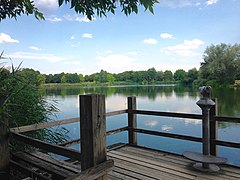
View over the "Baggerweiher" from the viewing platform in the north

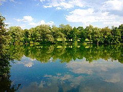
"Westpark" with a view over the quarry pond

Danube Park with Westbad in the background
South bank of the "Baggerweiher"

Bathing bay along the Danube Cycle Path in the Danube Park


literature
- City of Regensburg (Ed.): Street directory - city districts . December 7, 2015 ( digitized version [PDF]).
Web links
Individual evidence
- ^ The subdistricts of the city of Regensburg. City of Regensburg, accessed on September 14, 2016 .
- ^ Daniel Steffen: Newspaper clipping Mittelbayerische Zeitung - northernmost point of the Danube . In: Mittelbayerische.de . September 9, 2016. Retrieved May 19, 2018.
- ^ Geoportal City of Regensburg - Office for Urban Development . In: http://stadtplan2.regensburg.de/stadtplan.html . August 25, 2018. Retrieved August 25, 2018.
- ↑ Information board Schillerwiese City of Regensburg
- ^ Information board Donaupark City of Regensburg
- ↑ 50 Years Westheimsiedlung 1933–1983 , 1983.
- ↑ Newspaper clipping "Swimming, cycling and strolling on the northernmost bend of the Danube". Excerpt from the municipal article "Bei uns" of the city of Regensburg. September 2017
Coordinates: 49 ° 1 '24.7 " N , 12 ° 2' 56.6" E