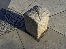
Three Free States Stone
The three-free state stone is the boundary stone that marks the triangle between the German states of Bavaria , Saxony and Thuringia . These three are the only federal states to officially bear the designation " Free State ".
The stone is located at the point where the districts of Münchenreuth (municipality of Feilitzsch , district of Hof , Bavaria), Grobau (municipality of Weischlitz , Vogtlandkreis , Saxony) and Gebersreuth (city of Gefell , Saale-Orla district , Thuringia) meet. This point was made by the border convention of the Kingdom of Saxony with the Kingdom of Bavaria of August 13, 1840 and with the Principality of Reuss younger lineof October 23, 1854 established as a triangle, which is why the abbreviations of these states - KB, KS and FR - are carved on the sides of the stone. Since the inner-German border opened , it has been freely accessible from all sides again and was inaugurated as a cultural monument on May 11, 2007. The stone was placed on a triangular slab over the course of the Kupferbach and can be reached on a hiking trail. The stand area is divided into three sub-areas, each of which is covered with natural stone representing a distinctive stone from the neighboring regions: Fichtelgebirge granite, Thuringian Muschelkalk and Theuma fruit slate .
Web links
Coordinates: 50 ° 25 ′ 27.6 ″ N , 11 ° 55 ′ 13.3 ″ E


