Grossbau
|
Grossbau
community Weischlitz
Coordinates: 50 ° 25 ′ 55 ″ N , 11 ° 56 ′ 43 ″ E
|
||
|---|---|---|
| Height : | 605 m above sea level NHN | |
| Area : | 5.53 km² | |
| Residents : | 121 (Dec. 31, 2013) | |
| Population density : | 22 inhabitants / km² | |
| Incorporation : | 4th July 1983 | |
| Incorporated into: | Kemnitz | |
| Postal code : | 08538 | |
| Primaries : | 037433, 037436 | |
|
Location of Grobau in Saxony |
||
Grobau is a district of the community Weischlitz in the Saxon Vogtlandkreis . It was incorporated into the municipality of Kemnitz on July 4, 1983 , which merged with six other municipalities to form the municipality of Burgstein on January 1, 1994 . This in turn was incorporated into the large community of Weischlitz on January 1, 2011.
geography
Location and traffic
Grobau is located in the west of the municipality Weischlitz on the upper reaches of the Kemnitzbach . It lies on the Weisse Elster - Saale watershed . The place borders on the Free States of Bavaria and Thuringia . The border triangle between Saxony, Bavaria and Thuringia forms the westernmost point of the Grobau district and the former municipality of Burgstein . The three free states stone located there marks this special border point where the three free states of Germany meet. Grobau is on the ridge path Erzgebirge – Vogtland , which also crosses the border triangle. The western corridor of Grobau borders on Bavaria and thus belongs to the Green Belt Germany nature reserve , which includes the former inner German border . The hamlet of Stöckigt in this former restricted area in the southern corridor of Grobau was destroyed in the course of the GDR border security on the inner German border in 1963.
Grobau is located in the west of the Vogtlandkreis and in the Saxon part of the historic Vogtland on the border with the Thuringian and Bavarian Vogtland . Geographically, the place is in the center of the natural area Vogtland ( Central Vogtland Kuppenland ).
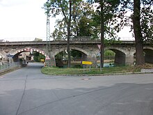
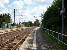
The Leipzig – Hof railway line runs directly through the town over a striking railway viaduct, under whose pillars the Grobau village pond is located. A separate stop is served by the Vogtland Railway and the Erfurt Railway .
Neighboring places
| Misslareuth | Reinhardtswalde | |
|
Gebersreuth with Straßenreuth (Thuringia) |

|
Kemnitz |
|
Münchenreuth (Bavaria) |
hallway stöckigt | Good lord |
history
The square village Grobau was mentioned as Grobowe in a document from 1302. The place was initially a chapel with its own clergy but was then Misslareuth gepfarrt that in a long time as so-called armed parish was called. Regarding the manor , Grobau belonged proportionally to the manors Kemnitz , Geilsdorf and Grobau in 1549 . In 1764 Grobau partly belonged to the Plauen council and the manors Geilsdorf and Grobau.
In 1549, two are in Grobau outworks detected, of which at least one was in 1580 in the family of Grünrod. Since 1606, one of the outbuildings has been occupied as a manor, which was owned by the von der Heydte men in the first half of the 18th century, the Adler family from the beginning of the 19th century and the Falkenbergs around 1925. The Grobau Vorwerk was subordinate to the Gutenfürst manor and, like it, belonged to the Lords of Feilitzsch and then to Walther von Nischwitz (1605) towards the end of the 16th century . The following owners were Joachim von Reibold and the gentlemen von der Heydte , who still owned the Vorwerk in 1925. While the Grobau Vorwerk is inhabited today, the Grobau manor was demolished in the 1970s.
Grobau and the hamlet of Stöckigt , located in Grobauer Flur and first mentioned in 1791, belonged to the Electoral Saxon and Royal Saxon Office of Plauen until 1856 . In 1856 Grobau and Stöckigt were affiliated to the Plauen court office and in 1875 to the Plauen administration . In 1848 the railway line of the Saxon-Bavarian Railway was built, which crosses the town in the center in a bridge. However, a separate stop was only opened in 1959.
After the Second World War, Grobau was increasingly affected by its proximity to the inner-German border . The place was in the 5 km exclusion zone and could only be reached with a pass. As a result of the second district reform in the GDR , the community of Grobau became part of the Plauen-Land district in the Chemnitz district in 1952 (renamed the Karl-Marx-Stadt district in 1953 ). The hamlet of Stöckigt , which belongs to Grobau , was completely destroyed by the GDR border troops in 1963. One reason for this was the 593 m high Zapfenstein south of the district, from which one had a good view of the Gutenfürst border station and the border apron.
On July 4, 1983, Grobau was incorporated into Kemnitz . With the fall of the Wall , the situation in the restricted area ended for Grobau. The former border strip has since been part of the Green Belt Germany nature reserve . As a district of the municipality of Kemnitz, Grobau belonged to the Saxon district of Plauen from 1990 onwards . On January 1, 1994, the municipality of Kemnitz merged with six other municipalities to form the municipality of Burgstein , which had belonged to the Vogtlandkreis since 1996. With the incorporation of the Burgstein community into the Weischlitz community, Grobau has been part of the Weischlitz community since January 1, 2011.
Attractions
As a special German feature, the three-free state stone marks the point where the three German free states of Saxony, Thuringia and Bavaria meet. The name of the path that leads from the former Stöckigt directly to Münchenreuth still tells of the border between the kingdoms of Saxony and Bavaria . It's called Paschersteig .
literature
- Grossbau . In: Voigtländischer Kreis (= album of the manors and castles in the kingdom of Saxony . Volume 5 ). Expedition of the Knightly Album Association, Leipzig 1859, p. 210 .
Web links
- Rough construction in the digital historical place directory of Saxony
- Stöckigt in the digital historical place directory of Saxony
- Rough construction on the website of the community Weischlitz
Individual evidence
- ^ Website of the Erzgebirge – Vogtland ridge trail
- ↑ The Kemnitz Manor at www.sachsens-schlösser.de
- ↑ Geilsdorf Castle at www.sachsens-schlösser.de
- ↑ The Grobau manor at www.sachsens-schlösser.de
- ↑ The Gutenfürst manor at www.sachsens-schlösser.de
- ↑ The Grobau manor at www.sachsens-schlösser.de
- ^ Karlheinz Blaschke , Uwe Ulrich Jäschke : Kursächsischer Ämteratlas. Leipzig 2009, ISBN 978-3-937386-14-0 ; P. 76 f.
- ^ The Plauen District Administration in the municipality register 1900
- ↑ The Grobau stop at www.sachsenschiene.net
- ↑ Stöckigt on a private website during the GDR era
- ↑ Grobau on gov.genealogy.net
- ↑ Kemnitz on gov.genealogy.net
- ^ Burgstein on gov.genealogy.net


