Misslareuth
|
Misslareuth
community Weischlitz
Coordinates: 50 ° 26 ′ 37 ″ N , 11 ° 54 ′ 24 ″ E
|
||
|---|---|---|
| Height : | 622 m above sea level NN | |
| Area : | 7.98 km² | |
| Residents : | 160 (1990) | |
| Population density : | 20 inhabitants / km² | |
| Incorporation : | March 1, 1994 | |
| Incorporated into: | Reuth | |
| Postal code : | 08538 | |
| Area code : | 037435 | |
|
Location of Misslareuth in Saxony |
||
|
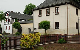
Historical building complex on the village square
|
||
Misslareuth is a district of the municipality Weischlitz in the Vogtlandkreis in Saxony . It was incorporated into the municipality of Reuth on March 1, 1994 , with which the place came to the municipality of Weischlitz on January 1, 2017.
geography
Location and traffic
The square village with hoof-like block and striped corridor is the westernmost part of the municipality Weischlitz. It borders on Thuringia in the north, west and south . Misslareuth lies between the Rosenbühl in the northwest and the Galgenpöhl in the east. The Kemnitzbach , a tributary of the White Elster, rises in the corridor . Misslareuth is located in the west of the Vogtlandkreis and in the Saxon part of the historical Vogtland . Geographically, the place is in the southwest of the natural area Vogtland (transition from southeast Thuringian slate mountains to the central Vogtland hill country ).
The Thuringian state road 1093 connects the place with the federal highway 2 , the federal highway 9 and the federal highway 72 as well as with the centers Schleiz and Plauen . In the area of the Saxon Misslareuth it is called Saxon State Road 287 . In the east, the Misslareuth corridor is affected by the Leipzig – Hof railway line .
Neighboring places
|
Rothenacker Thuringia |
Spielmes Thuringia |
|
|
Haidefeld Thuringia |

|
Reinhardtswalde |
|
Gebersreuth Thuringia |
Grossbau |
history
The first written mention of the place took place in 1289, when a pastor ("plebanus") was mentioned in "Muzcellotenrute". He was a witness to a contractual agreement between the bailiffs of Weida and Plauen . The local church was a so-called armed parish until the 19th century . Regarding the place name, there have been several name changes up to the current version of Misslareuth from 1590.
A manor was mentioned in the place in 1542. It was first owned by the von der Heydte family for a long time, then the von Feilitzsch family . The building was demolished in the mid-1990s. Regarding the manorial belonged Misslareuth proportion to the manors Misslareuth and Gutenfürst , the Lords of Rabenstein , the parish Misslareuth and as office Village for office Voigstberg . In 1764 only the Mißlareuth manor is still occupied. Until 1856, the place belonged as an exclave to the Electoral Saxon or Royal Saxon Office of Voigtsberg . In 1856 Misslareuth was affiliated to the Plauen court office and in 1875 to the Plauen administration . The population of the place increased from 269 in 1834 to 324 in 1910.
In the course of the second district reform in the GDR , the municipality of Misslareuth first came to the (previously Thuringian) district of Schleiz in the Gera district on July 5, 1952 , but became the (previously Saxon) district of Plauen-Land in the Chemnitz district on December 4, 1952 (1953 renamed to the Karl-Marx-Stadt district ), which was continued as the Saxon district of Plauen from 1990 onwards.
On March 1, 1994, Misslareuth was incorporated into Reuth . Reuth has been part of the Vogtland district since 1996. With the incorporation of the Reuth community into the Weischlitz community, Misslareuth has been part of Weischlitz since January 1, 2017.
Attractions
The Protestant Johanneskirche is a plastered stone building. The time of construction of the church building should be in the Romanesque period. Originally it was a branch of St. Lorenz in Hof in the diocese of Bamberg . Inside there are baroque fittings, such as the wooden pulpit and a font, the latter dating from 1729. The organ from 1862 is the work of Johann Gotthilf Bärmig from Werdau . The church tower also formed a now historical 2nd order trigonometric point of the Royal Saxon Triangulation with the number 157.
literature
- Richard Steche : Misslareuth. In: Descriptive representation of the older architectural and art monuments of the Kingdom of Saxony. 11th booklet: Amtshauptmannschaft Plauen . CC Meinhold, Dresden 1888, p. 29.
Web links
- Misslareuth in the Digital Historical Directory of Saxony
- Misslareuth on the website of the community Weischlitz
Individual evidence
- ↑ The Misslareuth manor at www.sachsens-schlösser.de
- ↑ The Gutenfürst manor at www.sachsens-schlösser.de
- ^ Karlheinz Blaschke , Uwe Ulrich Jäschke : Kursächsischer Ämteratlas. Leipzig 2009, ISBN 978-3-937386-14-0 ; P. 74 f.
- ^ The Plauen District Administration in the municipality register 1900
- ↑ Federal Statistical Office (Ed.): Municipalities 1994 and their changes since 01.01.1948 in the new federal states . Metzler-Poeschel, Stuttgart 1995, ISBN 3-8246-0321-7 .
- ↑ Misslareuth on gov.genealogy.net
- ^ Reuth on gov.genealogy.net
- ^ Georg Dehio : Handbook of German Art Monuments, Saxony II, administrative districts of Leipzig and Chemnitz . edited by Barbara Becker, Wiebke Fastenrath, Heinrich Magirius et al., Munich 1998, pp. 692–693
- ↑ Werner Pöllmann : The Johanneskirche to Misslareuth . In: Curt Röder: Vogtländisches Jahrbuch, 10th year 1993, Plauen, pp. 88-89 ISBN 3-9290-3926-5
- ↑ Thomas Quaiser: Stations of Central European Degree Measurement and the Royal Saxon Triangulation in Saxony 1862-1890 . on www.primacom.net


