Drissa (river)
|
Drissa Dryssa, Drisa |
||
|
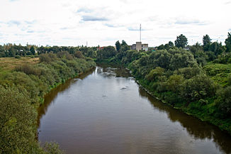
The Drissa near Verkhnyadswinsk |
||
| Data | ||
| location | Vitebskaya Woblasz ( Belarus ) | |
| River system | Daugava | |
| Drain over | Düna → Baltic Sea | |
| origin | Lake Drissa 55 ° 55 ′ 37 ″ N , 29 ° 23 ′ 5 ″ E |
|
| muzzle | north of Verkhnyadswinsk in the Daugava Coordinates: 55 ° 47 ′ 24 " N , 27 ° 55 ′ 51" E 55 ° 47 ′ 24 " N , 27 ° 55 ′ 51" E
|
|
| length | 183 km | |
| Catchment area | 6420 km² | |
| Discharge at the Verkhnyadswinsk gauge |
MQ |
40 m³ / s |
|
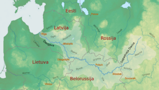
The Drissa in the catchment area of the Daugava |
||
|
Dilapidated bridge over the Drissa near Lake Busa on the border with Russia |
||
|
Mouth of the Drissa in the Daugava |
||
The Drissa ( Belarusian Дрыса Dryssa; Russian Дри́сса / Дры́са Drissa / Dryssa; Polish Dryssa ; Lithuanian Drisa ; Latvian Drisa ) is a right tributary of the Daugava in Belarus .
It flows through the Rajone Verkhnyadzvinsk and Rassony the north of the Vitebsk Region in the northeast of Belarus. With a total length of 183 km it drains a catchment area of 6420 km² (of which 1500 km² in Russia), which is mainly in the Polotsker lowlands.
The water flow at the confluence with the Düna north of Verkhnyadswinsk , which was called Drissa until 1962, is 40 m³ / s. Lake Drissa, from which it rises, continues in the border area between Russia and Belarus into a number of other lakes (Astrauzy / Ostrowzy, Sinscha, Busa).
Web links
Individual evidence
- ↑ a b c Article Drissa in the Great Soviet Encyclopedia (BSE) , 3rd edition 1969–1978 (Russian)


