Duchateau Islands
| Duchateau Islands | ||
|---|---|---|
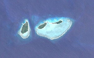
| NASA satellite image of the Duchateau Islands | ||
| Waters | Solomon Lake | |
| archipelago | Louisiade Archipelago | |
| Geographical location | 11 ° 17 ′ S , 152 ° 23 ′ E | |
|
|
||
| Number of islands | 3 | |
| Main island | Pana Bobai Ana | |
| Total land area | 1.49 km² | |
| Residents | uninhabited | |
The Duchateau Islands are an uninhabited group of islands in the Louisiade archipelago . Politically, they belong to the Milne Bay province in the southeastern part of Papua New Guinea .
The Duchateau Islands are a small group of three low islands on the southwestern edge of the Vanatinai Barrier Reef . They are located 5 km southeast of the Jomard Islands and immediately northeast of the Montemont Islands . Of the three islands, Pana Bobai Ana (75 ha ) is the largest island in the west. The two smaller islands Pana Rura Wara (42 ha) and Kukuluba (32 ha) are located on the north side of a reef-fringed lagoon .
Web links
- Duchateau Islands ( Memento from December 23, 2010 in the Internet Archive ) on Oceandots.com (further information & pictures) (English)

