Duke of York Island
| Duke of York Island | ||
|---|---|---|
| Satellite photo of the island | ||
| Waters | Bismarcksee | |
| Archipelago | Duke of York Islands | |
| Geographical location | 4 ° 10 ′ S , 152 ° 27 ′ E | |
|
|
||
| length | 11.1 km | |
| width | 9.8 km | |
| surface | 51.8 km² | |
| Highest elevation | 4 m | |
| main place | Utuan | |
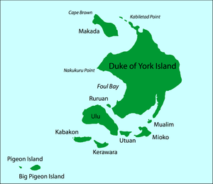
| Map of the Duke of York Islands. | ||
The Duke of York Island (formerly also Amacata or Amakada, in colonial German Neulauenburg) is an island of Papua New Guinea . It belongs to the group of the same name, the Duke of York Islands , which is located in the western Pacific between the much larger islands of New Britain in the west and New Ireland in the east.
The coral island is flat throughout and has an area of almost 52 km². Large bays can be found on the west coast (such as Foul Bay ).
1767 British sailors discovered Philip Carteret the island and named it and the surrounding islands in honor of the then Duke of York ( Duke of York ) Eduard August . Around 1884 they became a German colony, after the First World War they fell to Great Britain and since 1975 they have belonged to the state of Papua New Guinea .
Duke of York Island and its neighboring islands are located in an area prone to flooding, earthquakes and tsunamis . In 2000, the relocation of many inhabitants of the islands to higher areas of the islands of New Britain and New Ireland was announced in order to avoid deaths if the archipelago should sink.
Web links
- Evacuation from Rising Seas Planned for Pacific Islanders - 1,000 flee as sea begins to swallow up Pacific islands. In: The Heat is Online , 2000 (English; resettlement program).
Individual evidence
- ^ Author collective: Amakada. In: Brockhaus' Konversationslexikon , 14th edition. FA Brockhaus, Leipzig Berlin Vienna 1894–1896, Volume 1, p. 489.
- ^ Karl Sapper : Neulauenburg. In: Heinrich Schnee (Ed.): German Colonial Lexicon . Quelle and Meyer, Leipzig 1920, Volume 2, p. 633.


