Dyrøybrua
Coordinates: 69 ° 5 ′ 23 " N , 17 ° 34 ′ 40" E
| Dyrøybrua | ||
|---|---|---|
| Dyrøybrua | ||
| use | Road traffic | |
| Convicted | Fylkesvei 212 | |
| Crossing of | Dyrøysund | |
| place | Dyrøy , Norway | |
| construction | Cantilever bridge | |
| overall length | 570 m | |
| Longest span | 220 m | |
| Clear height | 18 m | |
| completion | 1994 | |
| opening | 1994 | |
| location | ||
|
|
||
| Above sea level | 0 m | |
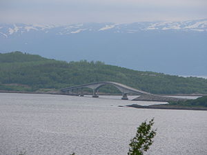
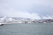
The Dyrøybrua ( Dyrøy Bridge ) is a cantilever road bridge in the Norwegian municipality of Dyrøy , Fylke (province) Troms og Finnmark .
The bridge crosses Dyrøysund and connects the island of Dyrøya at its northeastern end, the Ørnnes headland, with the mainland at Finnlandsnes about 3 km northwest of Brøstadbotn, the administrative center of Dyrøy municipality. The provincial road Fv212 Brøstadbotn extends from the bridge and then along the entire eastern shore of the island. From Brøstadbotn, the Fv852 provides a connection to the Rv84 and thus to the Norwegian road network.
The bridge replaced a ferry connection and was inaugurated on August 29, 1994. It is 570 m long and has 7 arches. The main arch with the ship passage is 220 m wide and has a clearance height of 18 m.


